Pogănești elevation
Pogănești (Vaslui, Comuna Stănileşti), Romania elevation is 20 meters and Pogănești elevation in feet is 66 ft above sea level [src 1]. Pogănești is a populated place (feature code) with elevation that is 232 meters (761 ft) smaller than average city elevation in Romania.
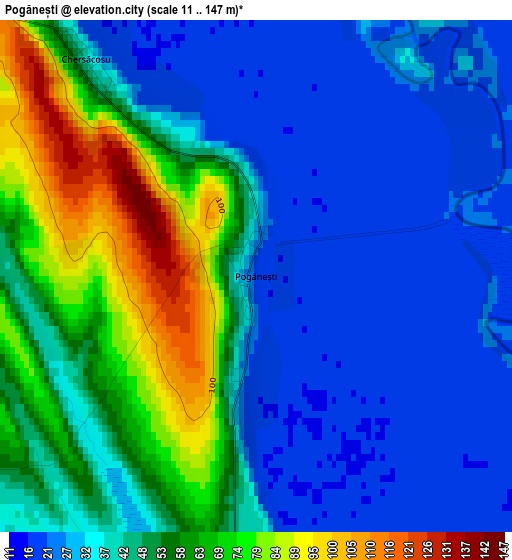
Below is the Elevation map of Pogănești, which displays elevation range with different colors. Scale of the first map is from 11 to 147 m (36 to 482 ft) with average elevation of 44.1 meters (=145 ft) [note 1]
These maps also provides idea of topography and contour of this city, they are displayed at different zoom levels. More info about maps, scale and edge coordinates you can find below images.
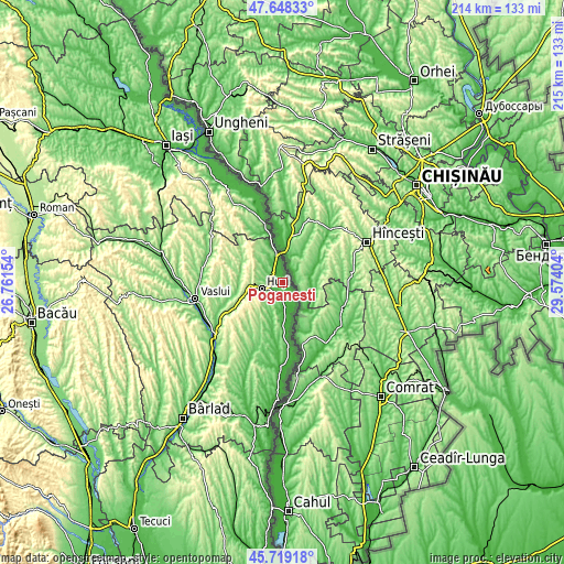
| \ | Map #1 | Topo.Map |
| Scale [m] | 11..147 m | × |
| Scale [ft] | 36..482 ft | × |
| Average | 44.1 m = 145 ft | × |
| Width | 6.7 km = 4.2 mi | 214.5 km = 133.3 mi |
| Height | 6.7 km = 4.2 mi | 214.5 km = 133.3 mi |
| ↑Max Latitude | 46.722504° | 47.64833° |
| Latitude at center | 46.69237° | 46.69237° |
| ↓Min Latitude | 46.662219° | 45.71918° |
| ← Min Longitude | 28.123845° | 26.76154° |
| Longitude center | 28.16779° | 28.16779° |
| →Max Longitude | 28.211735° | 29.57404° |
Nearby cities:
Cities around Pogănești sort by population:
• Huşi elevation 98 m
8.5 km,  255°
255°
• Văleni 163 m
13.7 km,  215°
215°
• Stănileşti 47 m
8.2 km,  178°
178°
• Duda 204 m
12 km,  303°
303°
• Băile Drânceni 55 m
14.4 km,  339°
339°
• Lunca Banului 39 m
10.8 km, 179°
• Râșești 34 m
9.1 km,  347°
347°
• Epureni 133 m
10 km,  279°
279°
• Valea Grecului 53 m
5.9 km, 301°
• Pădureni 122 m
10.2 km, 219°
• Tătărăni 171 m
15.5 km,  270°
270°
• Drânceni 32 m
12.4 km, 347°
Multilingual:
 En español:
Pogănești elevación 20 m.
 En France:
Pogănești élévation 20 m.
 Auf Deutsch:
Pogănești höhe über dem Meeresspiegel ist 20 m.

Sources and notes:
- [note 1] Map square and city borders are not equal. Map elevation data is calculated only from area inside that square.
- [src 1] Elevation data from geonames database provided with same terms of usage.
- [src 2] The elevation map of Pogănești is generated using elevation data from NASA's 3 arcsec (90m) resolution SRTM data.
- [src 3] Base (background) map © OpenStreetMap contributors tiles are generated by Geofabrik and OpenTopoMap.
Copyright & License:
This Pogănești Elevation Map is licensed under CC BY-SA. You may reuse any part from this page, if you give a proper credit by linking to this URL:
 More info on terms of use page.