Dumbrăvița elevation
Dumbrăvița (Iaşi, Comuna Ruginoasa), Romania elevation is 306 meters and Dumbrăvița elevation in feet is 1004 ft above sea level [src 1]. Dumbrăvița is a populated place (feature code) with elevation that is 54 meters (177 ft) bigger than average city elevation in Romania.
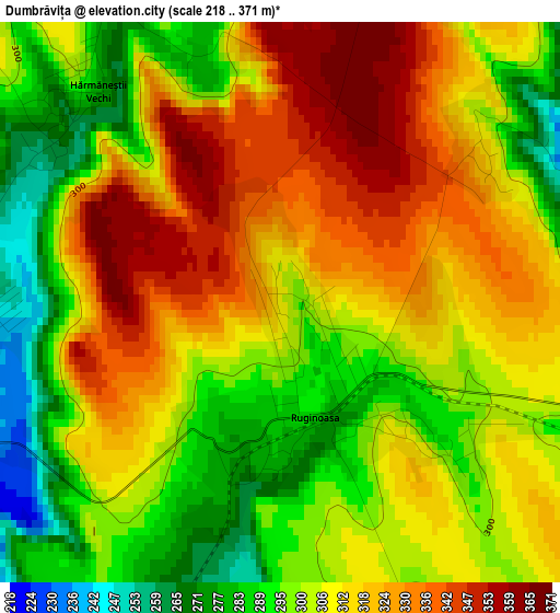
Below is the Elevation map of Dumbrăvița, which displays elevation range with different colors. Scale of the first map is from 218 to 371 m (715 to 1217 ft) with average elevation of 308.9 meters (=1013 ft) [note 1]
These maps also provides idea of topography and contour of this city, they are displayed at different zoom levels. More info about maps, scale and edge coordinates you can find below images.
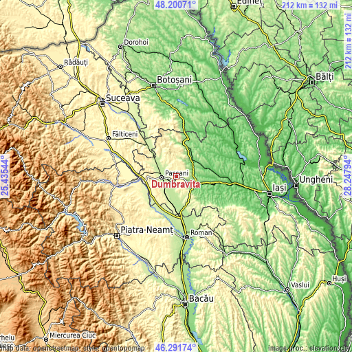
| \ | Map #1 | Topo.Map |
| Scale [m] | 218..371 m | × |
| Scale [ft] | 715..1217 ft | × |
| Average | 308.9 m = 1013 ft | × |
| Width | 6.63 km = 4.1 mi | 212.3 km = 131.9 mi |
| Height | 6.63 km = 4.1 mi | 212.2 km = 131.9 mi |
| ↑Max Latitude | 47.284649° | 48.20071° |
| Latitude at center | 47.25483° | 47.25483° |
| ↓Min Latitude | 47.224994° | 46.29174° |
| ← Min Longitude | 26.797745° | 25.43544° |
| Longitude center | 26.84169° | 26.84169° |
| →Max Longitude | 26.885635° | 28.24794° |
Nearby cities:
Cities around Dumbrăvița sort by population:
• Paşcani elevation 242 m
9 km,  264°
264°
• Todireşti 371 m
6.9 km,  354°
354°
• Ruginoasa 293 m
0.8 km,  130°
130°
• Stolniceni-Prăjescu 239 m
9.4 km,  228°
228°
• Hărmăneasa 275 m
6.4 km,  162°
162°
• Lunca 212 m
8.4 km,  290°
290°
• Crivești 264 m
8.9 km,  329°
329°
• Cucuteni 282 m
7.6 km,  65°
65°
• Rediu 293 m
2.3 km, 133°
• Costești 157 m
6.8 km,  109°
109°
• Hărmăneștii Vechi 272 m
3.3 km,  320°
320°
• Heleșteni 263 m
6.4 km,  154°
154°
Multilingual:
 En español:
Dumbrăvița elevación 306 m.
 En France:
Dumbrăvița élévation 306 m.
 Auf Deutsch:
Dumbrăvița höhe über dem Meeresspiegel ist 306 m.

Sources and notes:
- [note 1] Map square and city borders are not equal. Map elevation data is calculated only from area inside that square.
- [src 1] Elevation data from geonames database provided with same terms of usage.
- [src 2] The elevation map of Dumbrăvița is generated using elevation data from NASA's 3 arcsec (90m) resolution SRTM data.
- [src 3] Base (background) map © OpenStreetMap contributors tiles are generated by Geofabrik and OpenTopoMap.
Copyright & License:
This Dumbrăvița Elevation Map is licensed under CC BY-SA. You may reuse any part from this page, if you give a proper credit by linking to this URL:
 More info on terms of use page.