Fântânele elevation
Fântânele (Mureş, Comuna Fântânele), Romania elevation is 330 meters and Fântânele elevation in feet is 1083 ft above sea level [src 1]. Fântânele is a seat of a second-order administrative division (feature code) with elevation that is 78 meters (256 ft) bigger than average city elevation in Romania.
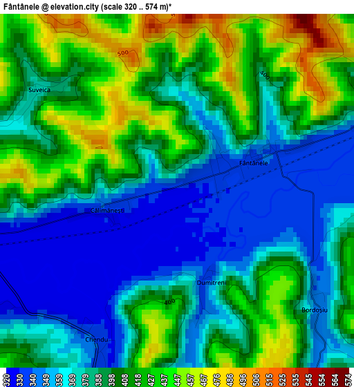
Below is the Elevation map of Fântânele, which displays elevation range with different colors. Scale of the first map is from 320 to 574 m (1050 to 1883 ft) with average elevation of 393.4 meters (=1291 ft) [note 1]
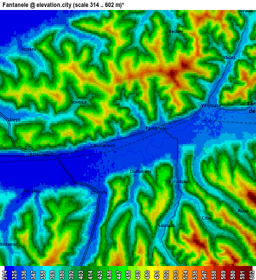
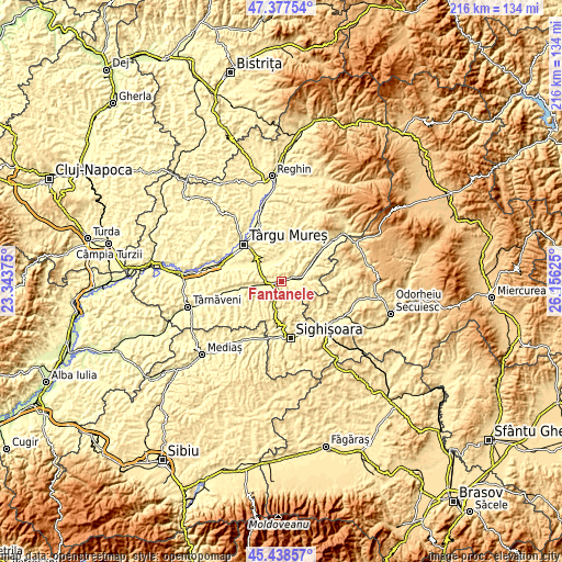
These maps also provides idea of topography and contour of this city, they are displayed at different zoom levels. More info about maps, scale and edge coordinates you can find below images.
| \ | Map #1 | Map #2 | Topo.Map |
| Scale [m] | 320..574 m | 314..602 m | × |
| Scale [ft] | 1050..1883 ft | 1030..1975 ft | × |
| Average | 393.4 m = 1291 ft | 405.5 m = 1330 ft | × |
| Width | 6.74 km = 4.2 mi | 13.47 km = 8.4 mi | 215.6 km = 134 mi |
| Height | 6.74 km = 4.2 mi | 13.47 km = 8.4 mi | 215.6 km = 134 mi |
| ↑Max Latitude | 46.446958° | 46.477229° | 47.37754° |
| Latitude at center | 46.41667° | 46.41667° | 46.41667° |
| ↓Min Latitude | 46.386365° | 46.356044° | 45.43857° |
| ← Min Longitude | 24.706055° | 24.662109° | 23.34375° |
| Longitude center | 24.75° | 24.75° | 24.75° |
| →Max Longitude | 24.793945° | 24.837891° | 26.15625° |
Nearby cities:
Cities around Fântânele sort by population:
• Bălăuşeri elevation 319 m
5.4 km,  250°
250°
• Sângeorgiu de Pădure 342 m
7.3 km,  77°
77°
• Acăţari 323 m
11.4 km,  308°
308°
• Găleşti 402 m
11.1 km,  0°
0°
• Nadeş 431 m
11.2 km,  186°
186°
• Păsăreni 321 m
8.3 km,  332°
332°
• Chendu 330 m
3.1 km,  210°
210°
• Neaua 412 m
9.8 km,  40°
40°
• Coroisânmartin 312 m
11.6 km,  260°
260°
• Zagăr 349 m
12.6 km,  234°
234°
• Trei Sate 364 m
13.1 km,  60°
60°
• Veţca 456 m
7.8 km,  160°
160°
Multilingual:
 En español:
Fântânele elevación 330 m.
 En France:
Fântânele élévation 330 m.
 Auf Deutsch:
Fântânele höhe über dem Meeresspiegel ist 330 m.

Sources and notes:
- [note 1] Map square and city borders are not equal. Map elevation data is calculated only from area inside that square.
- [src 1] Elevation data from geonames database provided with same terms of usage.
- [src 2] The elevation map of Fântânele is generated using elevation data from NASA's 3 arcsec (90m) resolution SRTM data.
- [src 3] Base (background) map © OpenStreetMap contributors tiles are generated by Geofabrik and OpenTopoMap.
Copyright & License:
This Fântânele Elevation Map is licensed under CC BY-SA. You may reuse any part from this page, if you give a proper credit by linking to this URL:
 More info on terms of use page.