Veţca elevation
Veţca (Mureş, Comuna Veţca), Romania elevation is 456 meters and Veţca elevation in feet is 1496 ft above sea level [src 1]. Veţca is a seat of a second-order administrative division (feature code) with elevation that is 204 meters (669 ft) bigger than average city elevation in Romania.
Below is the Elevation map of Veţca, which displays elevation range with different colors. Scale of the first map is from 352 to 592 m (1155 to 1942 ft) with average elevation of 460.7 meters (=1511 ft) [note 1]
These maps also provides idea of topography and contour of this city, they are displayed at different zoom levels. More info about maps, scale and edge coordinates you can find below images.
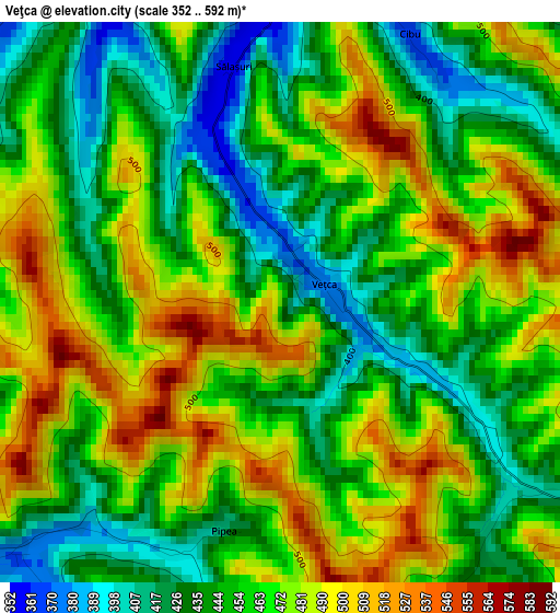
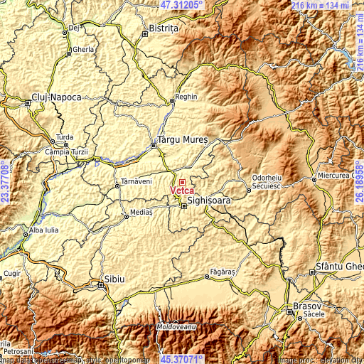
| \ | Map #1 | Topo.Map |
| Scale [m] | 352..592 m | × |
| Scale [ft] | 1155..1942 ft | × |
| Average | 460.7 m = 1511 ft | × |
| Width | 6.75 km = 4.2 mi | 215.9 km = 134.2 mi |
| Height | 6.75 km = 4.2 mi | 215.8 km = 134.1 mi |
| ↑Max Latitude | 46.380325° | 47.31205° |
| Latitude at center | 46.35° | 46.35° |
| ↓Min Latitude | 46.319658° | 45.37071° |
| ← Min Longitude | 24.739385° | 23.37708° |
| Longitude center | 24.78333° | 24.78333° |
| →Max Longitude | 24.827275° | 26.18958° |
Nearby cities:
Cities around Veţca sort by population:
• Sighișoara elevation 358 m
14.3 km,  177°
177°
• Albeşti 367 m
13.9 km,  158°
158°
• Fântânele 330 m
7.8 km,  340°
340°
• Bălăuşeri 319 m
9.5 km,  305°
305°
• Sângeorgiu de Pădure 342 m
10.1 km,  26°
26°
• Nadeş 431 m
5.3 km,  226°
226°
• Chendu 330 m
6.3 km,  318°
318°
• Seleuș 343 m
13.8 km,  209°
209°
• Boiu 372 m
11.6 km,  143°
143°
• Săcel 384 m
12.8 km,  115°
115°
• Zagăr 349 m
12.8 km,  270°
270°
• Eliseni 394 m
13.4 km, 118°
Multilingual:
 En español:
Veţca elevación 456 m.
 En France:
Veţca élévation 456 m.


Sources and notes:
- [note 1] Map square and city borders are not equal. Map elevation data is calculated only from area inside that square.
- [src 1] Elevation data from geonames database provided with same terms of usage.
- [src 2] The elevation map of Veţca is generated using elevation data from NASA's 3 arcsec (90m) resolution SRTM data.
- [src 3] Base (background) map © OpenStreetMap contributors tiles are generated by Geofabrik and OpenTopoMap.
Copyright & License:
This Veţca Elevation Map is licensed under CC BY-SA. You may reuse any part from this page, if you give a proper credit by linking to this URL:
 More info on terms of use page.