Fârliug elevation
Fârliug (Caraş-Severin, Comuna Fârliug), Romania elevation is 183 meters and Fârliug elevation in feet is 600 ft above sea level [src 1]. Fârliug is a seat of a second-order administrative division (feature code) with elevation that is 69 meters (226 ft) smaller than average city elevation in Romania.
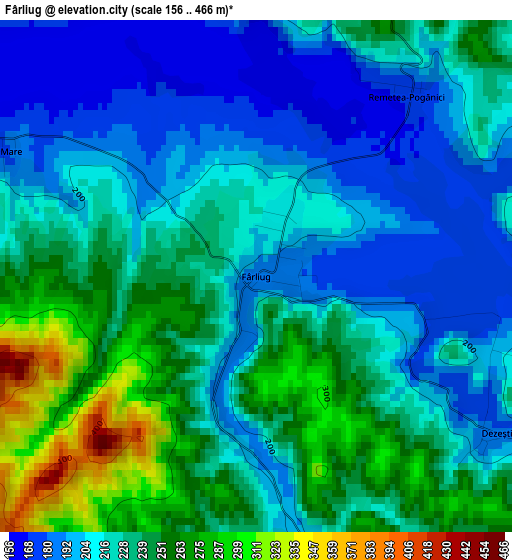
Below is the Elevation map of Fârliug, which displays elevation range with different colors. Scale of the first map is from 156 to 466 m (512 to 1529 ft) with average elevation of 225.5 meters (=740 ft) [note 1]
These maps also provides idea of topography and contour of this city, they are displayed at different zoom levels. More info about maps, scale and edge coordinates you can find below images.
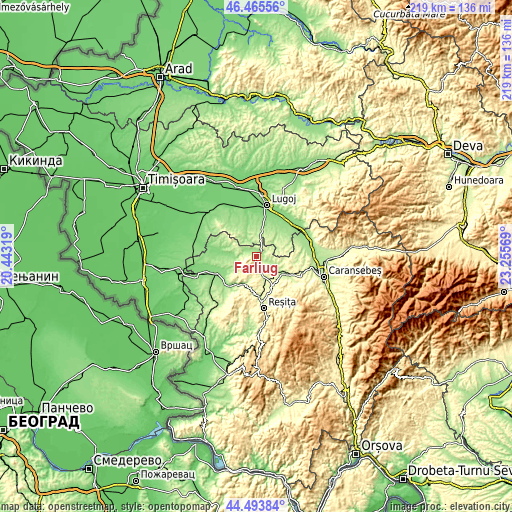
| \ | Map #1 | Topo.Map |
| Scale [m] | 156..466 m | × |
| Scale [ft] | 512..1529 ft | × |
| Average | 225.5 m = 740 ft | × |
| Width | 6.85 km = 4.3 mi | 219.2 km = 136.2 mi |
| Height | 6.85 km = 4.3 mi | 219.2 km = 136.2 mi |
| ↑Max Latitude | 45.51913° | 46.46556° |
| Latitude at center | 45.48833° | 45.48833° |
| ↓Min Latitude | 45.457514° | 44.49384° |
| ← Min Longitude | 21.805495° | 20.44319° |
| Longitude center | 21.84944° | 21.84944° |
| →Max Longitude | 21.893385° | 23.25569° |
Nearby cities:
Cities around Fârliug sort by population:
• Bocşa elevation 159 m
16.8 km,  220°
220°
• Darova Nouă 163 m
17.4 km,  338°
338°
• Victor Vlad Delamarina 139 m
17.3 km,  11°
11°
• Ştiuca 183 m
13.5 km,  47°
47°
• Ramna 153 m
13.7 km,  246°
246°
• Vermeş 136 m
15.2 km,  283°
283°
• Câlnic 208 m
16.7 km,  177°
177°
• Darova 156 m
18.1 km, 340°
• Ezeriş 221 m
9.1 km,  161°
161°
• Brebu 210 m
13.5 km,  124°
124°
• Sacoșu Mare 212 m
14.2 km,  319°
319°
• Zorlenţu Mare 192 m
9.3 km, 116°
Multilingual:
 En español:
Fârliug elevación 183 m.
 En France:
Fârliug élévation 183 m.


Sources and notes:
- [note 1] Map square and city borders are not equal. Map elevation data is calculated only from area inside that square.
- [src 1] Elevation data from geonames database provided with same terms of usage.
- [src 2] The elevation map of Fârliug is generated using elevation data from NASA's 3 arcsec (90m) resolution SRTM data.
- [src 3] Base (background) map © OpenStreetMap contributors tiles are generated by Geofabrik and OpenTopoMap.
Copyright & License:
This Fârliug Elevation Map is licensed under CC BY-SA. You may reuse any part from this page, if you give a proper credit by linking to this URL:
 More info on terms of use page.