Florești elevation
Florești (Giurgiu, Comună Floreşti-Stoeneşti), Romania elevation is 119 meters and Florești elevation in feet is 390 ft above sea level [src 1]. Florești is a populated place (feature code) with elevation that is 133 meters (436 ft) smaller than average city elevation in Romania.
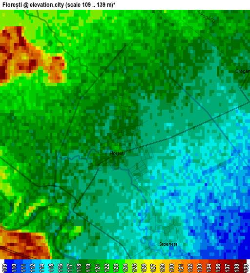
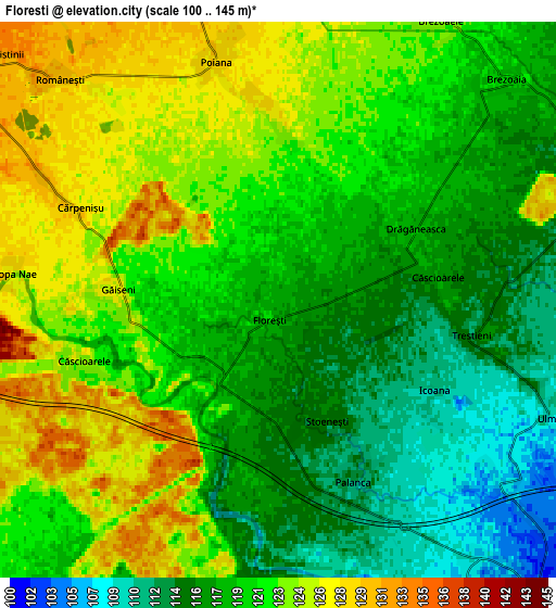
Below is the Elevation map of Florești, which displays elevation range with different colors. Scale of the first map is from 109 to 139 m (358 to 456 ft) with average elevation of 118.9 meters (=390 ft) [note 1]
These maps also provides idea of topography and contour of this city, they are displayed at different zoom levels. More info about maps, scale and edge coordinates you can find below images.
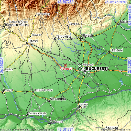
| \ | Map #1 | Map #2 | Topo.Map |
| Scale [m] | 109..139 m | 100..145 m | × |
| Scale [ft] | 358..456 ft | 328..476 ft | × |
| Average | 118.9 m = 390 ft | 120.2 m = 394 ft | × |
| Width | 6.97 km = 4.3 mi | 13.94 km = 8.7 mi | 223 km = 138.6 mi |
| Height | 6.97 km = 4.3 mi | 13.94 km = 8.7 mi | 223 km = 138.6 mi |
| ↑Max Latitude | 44.544459° | 44.57577° | 45.50728° |
| Latitude at center | 44.51313° | 44.51313° | 44.51313° |
| ↓Min Latitude | 44.481785° | 44.450422° | 43.50172° |
| ← Min Longitude | 25.652635° | 25.608689° | 24.29033° |
| Longitude center | 25.69658° | 25.69658° | 25.69658° |
| →Max Longitude | 25.740525° | 25.784471° | 27.10283° |
Nearby cities:
Cities around Florești sort by population:
• Bolintin Vale elevation 106 m
8.6 km,  145°
145°
• Ulmi 111 m
7.3 km,  113°
113°
• Găiseni 125 m
4.1 km,  272°
272°
• Poiana 126 m
6 km,  349°
349°
• Malu Spart 111 m
7.9 km,  167°
167°
• Palanca 112 m
4.8 km, 150°
• Trestieni 113 m
5 km,  101°
101°
• Brezoaia 115 m
8.5 km,  55°
55°
• Căscioarele 122 m
4.9 km,  251°
251°
• Stoenești 116 m
3.3 km,  158°
158°
• Brezoaele 125 m
8.3 km,  20°
20°
• Icoana 111 m
4.5 km,  119°
119°
Multilingual:
 En español:
Florești elevación 119 m.
 En France:
Florești élévation 119 m.
 Auf Deutsch:
Florești höhe über dem Meeresspiegel ist 119 m.

Sources and notes:
- [note 1] Map square and city borders are not equal. Map elevation data is calculated only from area inside that square.
- [src 1] Elevation data from geonames database provided with same terms of usage.
- [src 2] The elevation map of Florești is generated using elevation data from NASA's 3 arcsec (90m) resolution SRTM data.
- [src 3] Base (background) map © OpenStreetMap contributors tiles are generated by Geofabrik and OpenTopoMap.
Copyright & License:
This Florești Elevation Map is licensed under CC BY-SA. You may reuse any part from this page, if you give a proper credit by linking to this URL:
 More info on terms of use page.