Foglaş elevation
Foglaş (Bihor, Comuna Suplacu de Barcău), Romania elevation is 178 meters and Foglaş elevation in feet is 584 ft above sea level [src 1]. Foglaş is a populated place (feature code) with elevation that is 74 meters (243 ft) smaller than average city elevation in Romania.
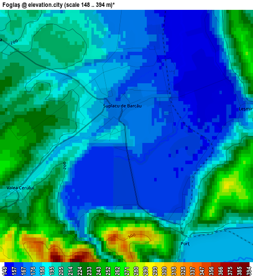
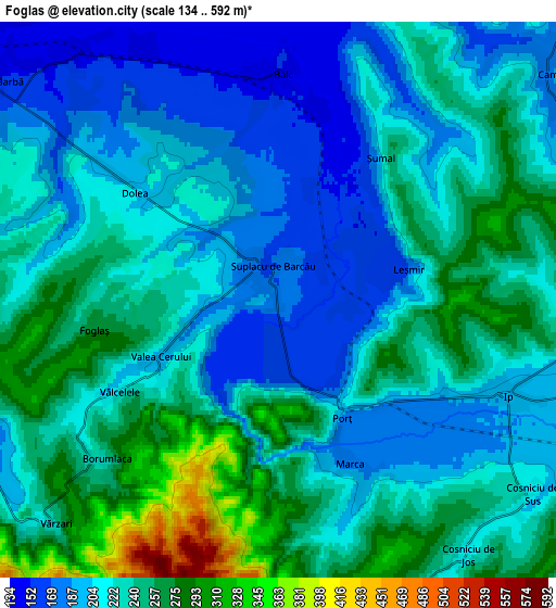
Below is the Elevation map of Foglaş, which displays elevation range with different colors. Scale of the first map is from 148 to 394 m (486 to 1293 ft) with average elevation of 197.5 meters (=648 ft) [note 1]
These maps also provides idea of topography and contour of this city, they are displayed at different zoom levels. More info about maps, scale and edge coordinates you can find below images.
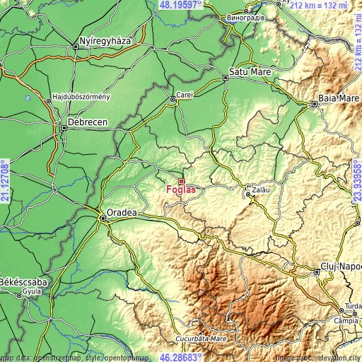
| \ | Map #1 | Map #2 | Topo.Map |
| Scale [m] | 148..394 m | 134..592 m | × |
| Scale [ft] | 486..1293 ft | 440..1942 ft | × |
| Average | 197.5 m = 648 ft | 226.2 m = 742 ft | × |
| Width | 6.63 km = 4.1 mi | 13.27 km = 8.2 mi | 212.3 km = 131.9 mi |
| Height | 6.63 km = 4.1 mi | 13.27 km = 8.2 mi | 212.3 km = 131.9 mi |
| ↑Max Latitude | 47.279822° | 47.309627° | 48.19597° |
| Latitude at center | 47.25° | 47.25° | 47.25° |
| ↓Min Latitude | 47.220161° | 47.190306° | 46.28683° |
| ← Min Longitude | 22.489385° | 22.445439° | 21.12708° |
| Longitude center | 22.53333° | 22.53333° | 22.53333° |
| →Max Longitude | 22.577275° | 22.621221° | 23.93958° |
Nearby cities:
Cities around Foglaş sort by population:
• Popeşti elevation 169 m
9 km,  258°
258°
• Ip 260 m
9 km,  101°
101°
• Balc 166 m
3.7 km,  0°
0°
• Marca 182 m
4.5 km,  145°
145°
• Suplacu de Barcău 169 m
0.8 km,  352°
352°
• Voivozi 190 m
11.5 km,  250°
250°
• Camăr 178 m
8.4 km,  48°
48°
• Cuzap 196 m
10.3 km,  239°
239°
• Şinteu 547 m
11.7 km,  198°
198°
• Zăuan 201 m
10.2 km,  105°
105°
• Bistra 176 m
8.3 km,  273°
273°
• Ciutelec 163 m
11.1 km,  276°
276°
Multilingual:
 En español:
Foglaş elevación 178 m.
 En France:
Foglaş élévation 178 m.


Sources and notes:
- [note 1] Map square and city borders are not equal. Map elevation data is calculated only from area inside that square.
- [src 1] Elevation data from geonames database provided with same terms of usage.
- [src 2] The elevation map of Foglaş is generated using elevation data from NASA's 3 arcsec (90m) resolution SRTM data.
- [src 3] Base (background) map © OpenStreetMap contributors tiles are generated by Geofabrik and OpenTopoMap.
Copyright & License:
This Foglaş Elevation Map is licensed under CC BY-SA. You may reuse any part from this page, if you give a proper credit by linking to this URL:
 More info on terms of use page.