Frăsinet elevation
Frăsinet (Călăraşi, Comuna Frăsinet), Romania elevation is 47 meters and Frăsinet elevation in feet is 154 ft above sea level [src 1]. Frăsinet is a seat of a second-order administrative division (feature code) with elevation that is 205 meters (673 ft) smaller than average city elevation in Romania.
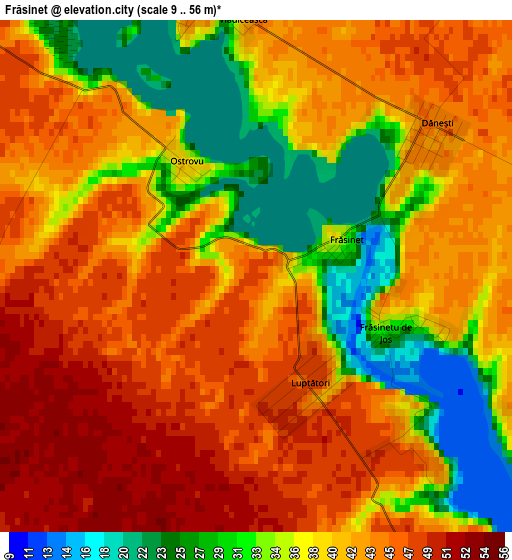
Below is the Elevation map of Frăsinet, which displays elevation range with different colors. Scale of the first map is from 9 to 56 m (30 to 184 ft) with average elevation of 39.8 meters (=131 ft) [note 1]
These maps also provides idea of topography and contour of this city, they are displayed at different zoom levels. More info about maps, scale and edge coordinates you can find below images.
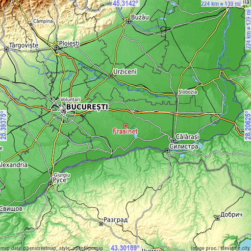
| \ | Map #1 | Topo.Map |
| Scale [m] | 9..56 m | × |
| Scale [ft] | 30..184 ft | × |
| Average | 39.8 m = 131 ft | × |
| Width | 6.99 km = 4.3 mi | 223.7 km = 139 mi |
| Height | 6.99 km = 4.3 mi | 223.7 km = 139 mi |
| ↑Max Latitude | 44.348104° | 45.3142° |
| Latitude at center | 44.31667° | 44.31667° |
| ↓Min Latitude | 44.285219° | 43.30189° |
| ← Min Longitude | 26.756055° | 25.39375° |
| Longitude center | 26.8° | 26.8° |
| →Max Longitude | 26.843945° | 28.20625° |
Nearby cities:
Cities around Frăsinet sort by population:
• Lehliu-Gară elevation 51 m
13.6 km,  17°
17°
• Mânăstirea 17 m
13.7 km,  144°
144°
• Lupşanu 48 m
10.9 km,  47°
47°
• Chiselet 24 m
15.4 km,  164°
164°
• Valea Argovei 21 m
3.9 km,  340°
340°
• Răzvani 49 m
13.3 km,  28°
28°
• Ulmu 21 m
10.8 km,  120°
120°
• Nicolae Bălcescu 56 m
15.1 km,  349°
349°
• Gurbăneşti 27 m
10.9 km,  312°
312°
• Radu Vodă 48 m
12.6 km, 52°
• Coconi 36 m
10.2 km, 138°
• Sultana 46 m
7.6 km,  145°
145°
Multilingual:
 En español:
Frăsinet elevación 47 m.
 En France:
Frăsinet élévation 47 m.


Sources and notes:
- [note 1] Map square and city borders are not equal. Map elevation data is calculated only from area inside that square.
- [src 1] Elevation data from geonames database provided with same terms of usage.
- [src 2] The elevation map of Frăsinet is generated using elevation data from NASA's 3 arcsec (90m) resolution SRTM data.
- [src 3] Base (background) map © OpenStreetMap contributors tiles are generated by Geofabrik and OpenTopoMap.
Copyright & License:
This Frăsinet Elevation Map is licensed under CC BY-SA. You may reuse any part from this page, if you give a proper credit by linking to this URL:
 More info on terms of use page.