Răzvani elevation
Răzvani (Călăraşi, Oraş Lehliu Garã), Romania elevation is 49 meters and Răzvani elevation in feet is 161 ft above sea level [src 1]. Răzvani is a populated place (feature code) with elevation that is 203 meters (666 ft) smaller than average city elevation in Romania.
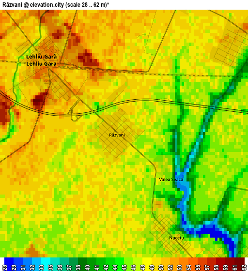
Below is the Elevation map of Răzvani, which displays elevation range with different colors. Scale of the first map is from 28 to 62 m (92 to 203 ft) with average elevation of 47.7 meters (=156 ft) [note 1]
These maps also provides idea of topography and contour of this city, they are displayed at different zoom levels. More info about maps, scale and edge coordinates you can find below images.
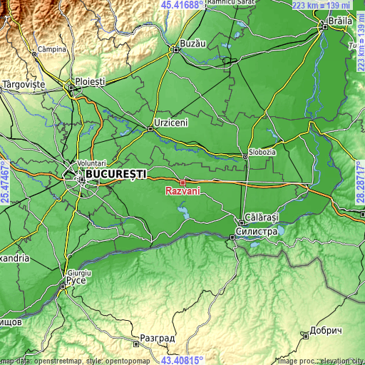
| \ | Map #1 | Topo.Map |
| Scale [m] | 28..62 m | × |
| Scale [ft] | 92..203 ft | × |
| Average | 47.7 m = 156 ft | × |
| Width | 6.98 km = 4.3 mi | 223.3 km = 138.8 mi |
| Height | 6.98 km = 4.3 mi | 223.3 km = 138.8 mi |
| ↑Max Latitude | 44.452518° | 45.41688° |
| Latitude at center | 44.42114° | 44.42114° |
| ↓Min Latitude | 44.389745° | 43.40815° |
| ← Min Longitude | 26.836975° | 25.47467° |
| Longitude center | 26.88092° | 26.88092° |
| →Max Longitude | 26.924865° | 28.28717° |
Nearby cities:
Cities around Răzvani sort by population:
• Dor Mărunt elevation 49 m
4.3 km,  41°
41°
• Lehliu-Gară 51 m
2.8 km,  298°
298°
• Lupşanu 48 m
4.5 km,  160°
160°
• Lehliu 46 m
7.2 km,  314°
314°
• Valea Argovei 21 m
11.1 km,  224°
224°
• Sălcioara 62 m
12.5 km,  0°
0°
• Frăsinet 47 m
13.3 km,  208°
208°
• Nicolae Bălcescu 56 m
9.6 km,  289°
289°
• Dâlga-Gară 48 m
13.5 km,  84°
84°
• Radu Vodă 48 m
5.3 km,  138°
138°
• Rași 66 m
13.2 km,  15°
15°
• Săpunari 59 m
9.6 km,  338°
338°
Multilingual:
 En español:
Răzvani elevación 49 m.
 En France:
Răzvani élévation 49 m.


Sources and notes:
- [note 1] Map square and city borders are not equal. Map elevation data is calculated only from area inside that square.
- [src 1] Elevation data from geonames database provided with same terms of usage.
- [src 2] The elevation map of Răzvani is generated using elevation data from NASA's 3 arcsec (90m) resolution SRTM data.
- [src 3] Base (background) map © OpenStreetMap contributors tiles are generated by Geofabrik and OpenTopoMap.
Copyright & License:
This Răzvani Elevation Map is licensed under CC BY-SA. You may reuse any part from this page, if you give a proper credit by linking to this URL:
 More info on terms of use page.