Fulga de Sus elevation
Fulga de Sus (Prahova, Comuna Fulga), Romania elevation is 78 meters and Fulga de Sus elevation in feet is 256 ft above sea level [src 1]. Fulga de Sus is a populated place (feature code) with elevation that is 174 meters (571 ft) smaller than average city elevation in Romania.
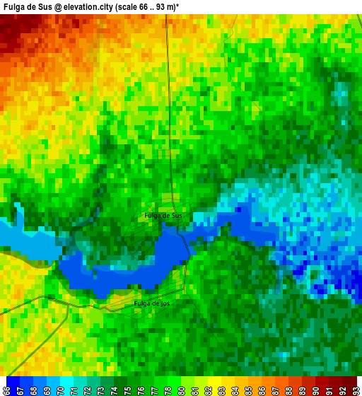
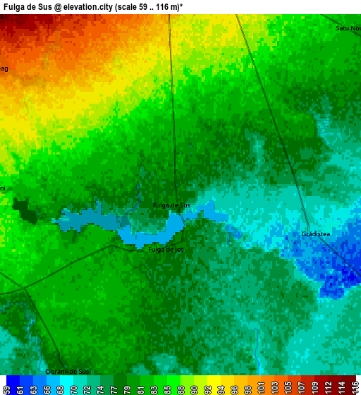
Below is the Elevation map of Fulga de Sus, which displays elevation range with different colors. Scale of the first map is from 66 to 93 m (217 to 305 ft) with average elevation of 77.5 meters (=254 ft) [note 1]
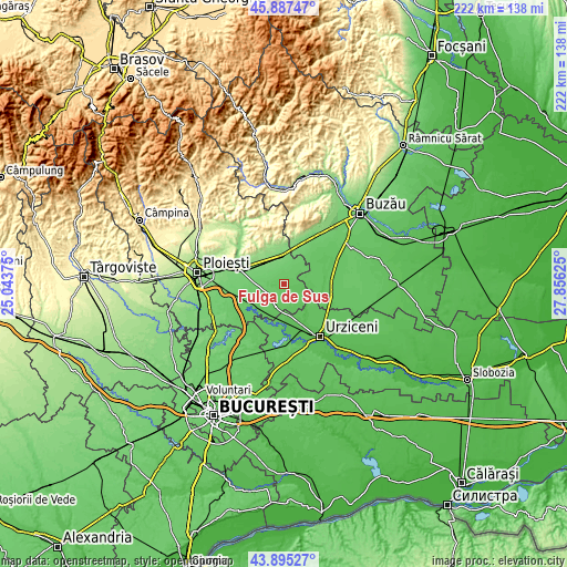
These maps also provides idea of topography and contour of this city, they are displayed at different zoom levels. More info about maps, scale and edge coordinates you can find below images.
| \ | Map #1 | Map #2 | Topo.Map |
| Scale [m] | 66..93 m | 59..116 m | × |
| Scale [ft] | 217..305 ft | 194..381 ft | × |
| Average | 77.5 m = 254 ft | 80.9 m = 265 ft | × |
| Width | 6.92 km = 4.3 mi | 13.84 km = 8.6 mi | 221.5 km = 137.6 mi |
| Height | 6.92 km = 4.3 mi | 13.84 km = 8.6 mi | 221.5 km = 137.6 mi |
| ↑Max Latitude | 44.93112° | 44.962223° | 45.88747° |
| Latitude at center | 44.9° | 44.9° | 44.9° |
| ↓Min Latitude | 44.868863° | 44.83771° | 43.89527° |
| ← Min Longitude | 26.406055° | 26.362109° | 25.04375° |
| Longitude center | 26.45° | 26.45° | 26.45° |
| →Max Longitude | 26.493945° | 26.537891° | 27.85625° |
Nearby cities:
Cities around Fulga de Sus sort by population:
• Cioranii de Jos elevation 76 m
9.6 km,  195°
195°
• Colceag 107 m
9.6 km,  305°
305°
• Baba Ana 99 m
7.4 km,  0°
0°
• Amaru 75 m
11.1 km,  70°
70°
• Cioranii de Sus 77 m
8 km,  212°
212°
• Sălciile 71 m
9.6 km,  164°
164°
• Inotești 114 m
10 km, 313°
• Boldeşti 75 m
8.7 km,  115°
115°
• Fulga de Jos 79 m
2.1 km, 195°
• Parepa-Rușani 86 m
7.5 km,  274°
274°
• Conduratu 108 m
8.1 km,  350°
350°
• Gradiștea 68 m
5.3 km,  104°
104°
Multilingual:
 En español:
Fulga de Sus elevación 78 m.
 En France:
Fulga de Sus élévation 78 m.
 Auf Deutsch:
Fulga de Sus höhe über dem Meeresspiegel ist 78 m.

Sources and notes:
- [note 1] Map square and city borders are not equal. Map elevation data is calculated only from area inside that square.
- [src 1] Elevation data from geonames database provided with same terms of usage.
- [src 2] The elevation map of Fulga de Sus is generated using elevation data from NASA's 3 arcsec (90m) resolution SRTM data.
- [src 3] Base (background) map © OpenStreetMap contributors tiles are generated by Geofabrik and OpenTopoMap.
Copyright & License:
This Fulga de Sus Elevation Map is licensed under CC BY-SA. You may reuse any part from this page, if you give a proper credit by linking to this URL:
 More info on terms of use page.