Sălciile elevation
Sălciile (Prahova, Comuna Sălciile), Romania elevation is 71 meters and Sălciile elevation in feet is 233 ft above sea level [src 1]. Sălciile is a seat of a second-order administrative division (feature code) with elevation that is 181 meters (594 ft) smaller than average city elevation in Romania.
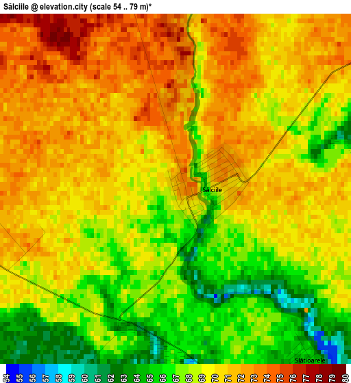
Below is the Elevation map of Sălciile, which displays elevation range with different colors. Scale of the first map is from 54 to 79 m (177 to 259 ft) with average elevation of 69.1 meters (=227 ft) [note 1]
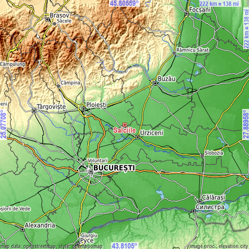
These maps also provides idea of topography and contour of this city, they are displayed at different zoom levels. More info about maps, scale and edge coordinates you can find below images.
| \ | Map #1 | Topo.Map |
| Scale [m] | 54..79 m | × |
| Scale [ft] | 177..259 ft | × |
| Average | 69.1 m = 227 ft | × |
| Width | 6.93 km = 4.3 mi | 221.8 km = 137.8 mi |
| Height | 6.93 km = 4.3 mi | 221.8 km = 137.8 mi |
| ↑Max Latitude | 44.847835° | 45.80559° |
| Latitude at center | 44.81667° | 44.81667° |
| ↓Min Latitude | 44.785488° | 43.8105° |
| ← Min Longitude | 26.439385° | 25.07708° |
| Longitude center | 26.48333° | 26.48333° |
| →Max Longitude | 26.527275° | 27.88958° |
Nearby cities:
Cities around Sălciile sort by population:
• Armăşeşti elevation 60 m
10.8 km,  133°
133°
• Cioranii de Jos 76 m
5.3 km,  270°
270°
• Fulga de Sus 78 m
9.6 km,  344°
344°
• Jilavele 59 m
6.8 km,  144°
144°
• Adâncata 64 m
6.8 km,  215°
215°
• Cioranii de Sus 77 m
7.4 km,  289°
289°
• Maia 72 m
11 km, 215°
• Boldeşti 75 m
7.5 km,  43°
43°
• Malu Roșu 63 m
8.6 km,  117°
117°
• Fulga de Jos 79 m
7.9 km, 335°
• Patru Frați 59 m
8.9 km,  186°
186°
• Gradiștea 68 m
8.3 km,  17°
17°
Multilingual:
 En español:
Sălciile elevación 71 m.
 En France:
Sălciile élévation 71 m.


Sources and notes:
- [note 1] Map square and city borders are not equal. Map elevation data is calculated only from area inside that square.
- [src 1] Elevation data from geonames database provided with same terms of usage.
- [src 2] The elevation map of Sălciile is generated using elevation data from NASA's 3 arcsec (90m) resolution SRTM data.
- [src 3] Base (background) map © OpenStreetMap contributors tiles are generated by Geofabrik and OpenTopoMap.
Copyright & License:
This Sălciile Elevation Map is licensed under CC BY-SA. You may reuse any part from this page, if you give a proper credit by linking to this URL:
 More info on terms of use page.