Gioseni elevation
Gioseni (Bacău, Comuna Gioseni), Romania elevation is 140 meters and Gioseni elevation in feet is 459 ft above sea level [src 1]. Gioseni is a populated place (feature code) with elevation that is 112 meters (367 ft) smaller than average city elevation in Romania.
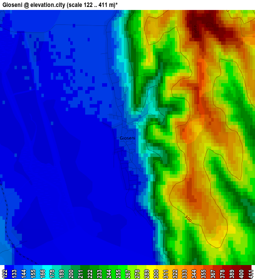
Below is the Elevation map of Gioseni, which displays elevation range with different colors. Scale of the first map is from 122 to 411 m (400 to 1348 ft) with average elevation of 200.1 meters (=656 ft) [note 1]
These maps also provides idea of topography and contour of this city, they are displayed at different zoom levels. More info about maps, scale and edge coordinates you can find below images.
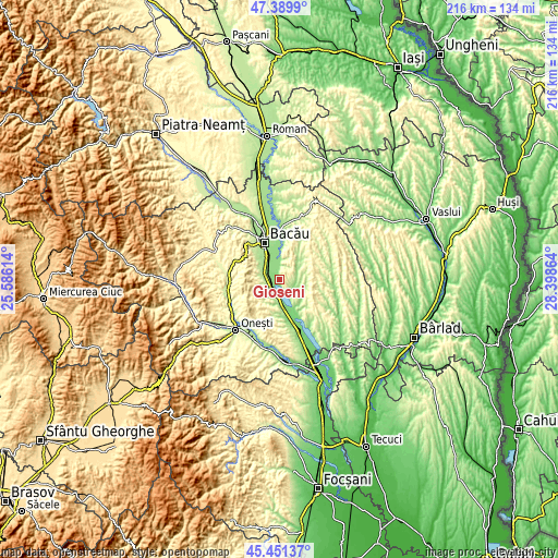
| \ | Map #1 | Topo.Map |
| Scale [m] | 122..411 m | × |
| Scale [ft] | 400..1348 ft | × |
| Average | 200.1 m = 656 ft | × |
| Width | 6.74 km = 4.2 mi | 215.5 km = 133.9 mi |
| Height | 6.74 km = 4.2 mi | 215.5 km = 133.9 mi |
| ↑Max Latitude | 46.459531° | 47.3899° |
| Latitude at center | 46.42925° | 46.42925° |
| ↓Min Latitude | 46.398952° | 45.45137° |
| ← Min Longitude | 26.948445° | 25.58614° |
| Longitude center | 26.99239° | 26.99239° |
| →Max Longitude | 27.036335° | 28.39864° |
Nearby cities:
Cities around Gioseni sort by population:
• Nicolae Bălcescu elevation 162 m
7.1 km,  305°
305°
• Cleja 249 m
7.2 km,  258°
258°
• Tamaşi 141 m
6.1 km,  353°
353°
• Faraoaní 206 m
7.1 km,  273°
273°
• Horgeşti 230 m
5.7 km,  85°
85°
• Parincea 216 m
10.2 km,  53°
53°
• Ungureni 141 m
10.2 km,  341°
341°
• Dămoc 261 m
10.5 km,  293°
293°
• Valea Seacă 229 m
9.4 km, 294°
• Somușca 273 m
6.9 km,  243°
243°
• Galbeni 136 m
4.6 km, 310°
• Gheorghe Doja 143 m
6.1 km,  202°
202°
Multilingual:
 En español:
Gioseni elevación 140 m.
 En France:
Gioseni élévation 140 m.


Sources and notes:
- [note 1] Map square and city borders are not equal. Map elevation data is calculated only from area inside that square.
- [src 1] Elevation data from geonames database provided with same terms of usage.
- [src 2] The elevation map of Gioseni is generated using elevation data from NASA's 3 arcsec (90m) resolution SRTM data.
- [src 3] Base (background) map © OpenStreetMap contributors tiles are generated by Geofabrik and OpenTopoMap.
Copyright & License:
This Gioseni Elevation Map is licensed under CC BY-SA. You may reuse any part from this page, if you give a proper credit by linking to this URL:
 More info on terms of use page.