Gârda de Sus elevation
Gârda de Sus (Alba, Comuna Gârda de Sus), Romania elevation is 849 meters and Gârda de Sus elevation in feet is 2785 ft above sea level [src 1]. Gârda de Sus is a seat of a second-order administrative division (feature code) with elevation that is 597 meters (1959 ft) bigger than average city elevation in Romania.
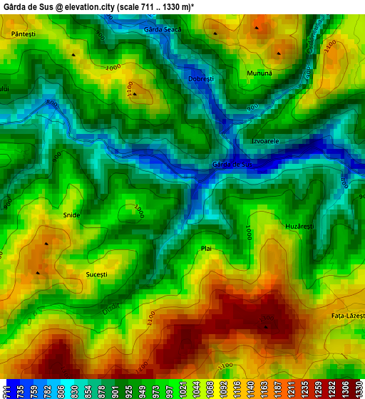
Below is the Elevation map of Gârda de Sus, which displays elevation range with different colors. Scale of the first map is from 711 to 1330 m (2333 to 4364 ft) with average elevation of 998.6 meters (=3276 ft) [note 1]
These maps also provides idea of topography and contour of this city, they are displayed at different zoom levels. More info about maps, scale and edge coordinates you can find below images.
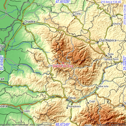
| \ | Map #1 | Topo.Map |
| Scale [m] | 711..1330 m | × |
| Scale [ft] | 2333..4364 ft | × |
| Average | 998.6 m = 3276 ft | × |
| Width | 6.73 km = 4.2 mi | 215.5 km = 133.9 mi |
| Height | 6.73 km = 4.2 mi | 215.4 km = 133.8 mi |
| ↑Max Latitude | 46.480269° | 47.41028° |
| Latitude at center | 46.45° | 46.45° |
| ↓Min Latitude | 46.419714° | 45.47249° |
| ← Min Longitude | 22.772725° | 21.41042° |
| Longitude center | 22.81667° | 22.81667° |
| →Max Longitude | 22.860615° | 24.22292° |
Nearby cities:
Cities around Gârda de Sus sort by population:
• Câmpeni elevation 559 m
20.1 km,  117°
117°
• Albac 626 m
10.3 km,  88°
88°
• Sohodol 555 m
19.4 km, 122°
• Arieşeni 834 m
5.4 km,  302°
302°
• Scărişoara 1113 m
3.2 km,  54°
54°
• Avram Iancu 837 m
7.8 km,  199°
199°
• Vadu Moţilor 705 m
12.8 km, 115°
• Nucet 392 m
20.2 km,  281°
281°
• Poiana Vadului 873 m
7.6 km,  137°
137°
• Horea 746 m
11.8 km,  60°
60°
• Vidra 642 m
10.7 km,  149°
149°
• Bulzeștii de Sus 506 m
17.1 km,  194°
194°
Multilingual:
 En español:
Gârda de Sus elevación 849 m.
 En France:
Gârda de Sus élévation 849 m.
 Auf Deutsch:
Gârda de Sus höhe über dem Meeresspiegel ist 849 m.

Sources and notes:
- [note 1] Map square and city borders are not equal. Map elevation data is calculated only from area inside that square.
- [src 1] Elevation data from geonames database provided with same terms of usage.
- [src 2] The elevation map of Gârda de Sus is generated using elevation data from NASA's 3 arcsec (90m) resolution SRTM data.
- [src 3] Base (background) map © OpenStreetMap contributors tiles are generated by Geofabrik and OpenTopoMap.
Copyright & License:
This Gârda de Sus Elevation Map is licensed under CC BY-SA. You may reuse any part from this page, if you give a proper credit by linking to this URL:
 More info on terms of use page.