Glod elevation
Glod (Dâmboviţa, Comuna Moroeni), Romania elevation is 628 meters and Glod elevation in feet is 2060 ft above sea level [src 1]. Glod is a populated place (feature code) with elevation that is 376 meters (1234 ft) bigger than average city elevation in Romania.
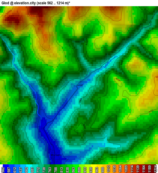
Below is the Elevation map of Glod, which displays elevation range with different colors. Scale of the first map is from 562 to 1214 m (1844 to 3983 ft) with average elevation of 817.2 meters (=2681 ft) [note 1]
These maps also provides idea of topography and contour of this city, they are displayed at different zoom levels. More info about maps, scale and edge coordinates you can find below images.
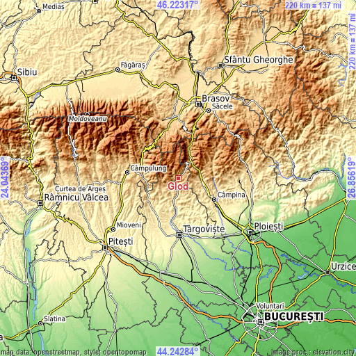
| \ | Map #1 | Topo.Map |
| Scale [m] | 562..1214 m | × |
| Scale [ft] | 1844..3983 ft | × |
| Average | 817.2 m = 2681 ft | × |
| Width | 6.88 km = 4.3 mi | 220.2 km = 136.8 mi |
| Height | 6.88 km = 4.3 mi | 220.2 km = 136.8 mi |
| ↑Max Latitude | 45.272564° | 46.22317° |
| Latitude at center | 45.24163° | 45.24163° |
| ↓Min Latitude | 45.210679° | 44.24284° |
| ← Min Longitude | 25.405995° | 24.04369° |
| Longitude center | 25.44994° | 25.44994° |
| →Max Longitude | 25.493885° | 26.85619° |
Nearby cities:
Cities around Glod sort by population:
• Fieni elevation 486 m
12.3 km,  192°
192°
• Bezdead 534 m
11.5 km,  152°
152°
• Moroeni 569 m
3.1 km,  205°
205°
• Buciumeni 475 m
10.2 km,  179°
179°
• Runcu 556 m
8.3 km,  218°
218°
• Pietroşiţa 575 m
6.6 km, 191°
• Valea Leurzii 580 m
9.3 km,  162°
162°
• Dealu Mare 508 m
9 km, 180°
• Lunca 563 m
4.6 km, 186°
• Talea 824 m
9.1 km,  101°
101°
• Bădeni 503 m
10.6 km,  200°
200°
• Dealu Frumos 673 m
6.8 km, 204°
Multilingual:
 En español:
Glod elevación 628 m.
 En France:
Glod élévation 628 m.


Sources and notes:
- [note 1] Map square and city borders are not equal. Map elevation data is calculated only from area inside that square.
- [src 1] Elevation data from geonames database provided with same terms of usage.
- [src 2] The elevation map of Glod is generated using elevation data from NASA's 3 arcsec (90m) resolution SRTM data.
- [src 3] Base (background) map © OpenStreetMap contributors tiles are generated by Geofabrik and OpenTopoMap.
Copyright & License:
This Glod Elevation Map is licensed under CC BY-SA. You may reuse any part from this page, if you give a proper credit by linking to this URL:
 More info on terms of use page.