Hăbeni elevation
Hăbeni (Dâmboviţa, Comuna Bucşani), Romania elevation is 206 meters and Hăbeni elevation in feet is 676 ft above sea level [src 1]. Hăbeni is a populated place (feature code) with elevation that is 46 meters (151 ft) smaller than average city elevation in Romania.
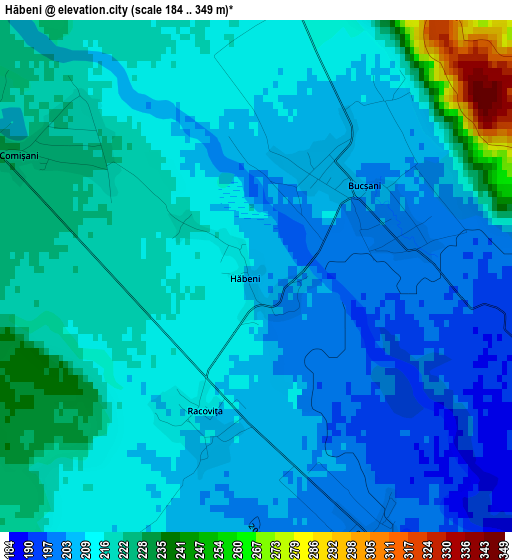
Below is the Elevation map of Hăbeni, which displays elevation range with different colors. Scale of the first map is from 184 to 349 m (604 to 1145 ft) with average elevation of 213.8 meters (=701 ft) [note 1]
These maps also provides idea of topography and contour of this city, they are displayed at different zoom levels. More info about maps, scale and edge coordinates you can find below images.
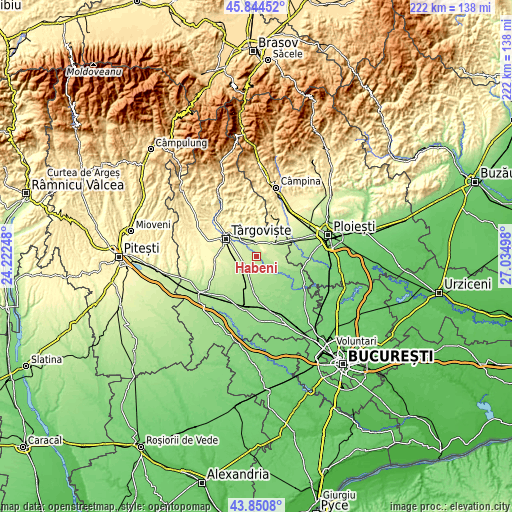
| \ | Map #1 | Topo.Map |
| Scale [m] | 184..349 m | × |
| Scale [ft] | 604..1145 ft | × |
| Average | 213.8 m = 701 ft | × |
| Width | 6.93 km = 4.3 mi | 221.7 km = 137.8 mi |
| Height | 6.93 km = 4.3 mi | 221.7 km = 137.8 mi |
| ↑Max Latitude | 44.887433° | 45.84452° |
| Latitude at center | 44.85629° | 44.85629° |
| ↓Min Latitude | 44.82513° | 43.8508° |
| ← Min Longitude | 25.584785° | 24.22248° |
| Longitude center | 25.62873° | 25.62873° |
| →Max Longitude | 25.672675° | 27.03498° |
Nearby cities:
Cities around Hăbeni sort by population:
• Băleni Sârbi elevation 202 m
4.4 km,  175°
175°
• Bucşani 204 m
2 km,  55°
55°
• Comişani 226 m
4.7 km,  310°
310°
• I. L. Caragiale 221 m
8.3 km,  44°
44°
• Mija 255 m
7.4 km,  30°
30°
• Adânca 235 m
7.5 km,  348°
348°
• Mărcești 178 m
8.5 km,  131°
131°
• Lazuri 236 m
6.7 km,  291°
291°
• Săcueni 237 m
7.5 km,  323°
323°
• Cazaci 210 m
8.5 km,  224°
224°
• Bungetu 230 m
7.3 km,  258°
258°
• Racovița 210 m
2 km,  198°
198°
Multilingual:
 En español:
Hăbeni elevación 206 m.
 En France:
Hăbeni élévation 206 m.


Sources and notes:
- [note 1] Map square and city borders are not equal. Map elevation data is calculated only from area inside that square.
- [src 1] Elevation data from geonames database provided with same terms of usage.
- [src 2] The elevation map of Hăbeni is generated using elevation data from NASA's 3 arcsec (90m) resolution SRTM data.
- [src 3] Base (background) map © OpenStreetMap contributors tiles are generated by Geofabrik and OpenTopoMap.
Copyright & License:
This Hăbeni Elevation Map is licensed under CC BY-SA. You may reuse any part from this page, if you give a proper credit by linking to this URL:
 More info on terms of use page.