Mărcești elevation
Mărcești (Dâmboviţa, Comuna Dobra), Romania elevation is 178 meters and Mărcești elevation in feet is 584 ft above sea level [src 1]. Mărcești is a populated place (feature code) with elevation that is 74 meters (243 ft) smaller than average city elevation in Romania.
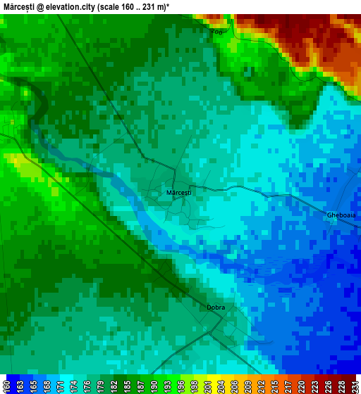
Below is the Elevation map of Mărcești, which displays elevation range with different colors. Scale of the first map is from 160 to 231 m (525 to 758 ft) with average elevation of 179.8 meters (=590 ft) [note 1]
These maps also provides idea of topography and contour of this city, they are displayed at different zoom levels. More info about maps, scale and edge coordinates you can find below images.
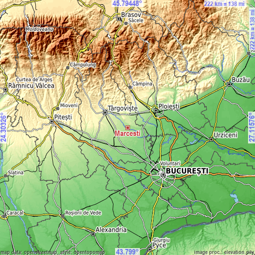
| \ | Map #1 | Topo.Map |
| Scale [m] | 160..231 m | × |
| Scale [ft] | 525..758 ft | × |
| Average | 179.8 m = 590 ft | × |
| Width | 6.93 km = 4.3 mi | 221.9 km = 137.9 mi |
| Height | 6.93 km = 4.3 mi | 221.9 km = 137.9 mi |
| ↑Max Latitude | 44.836541° | 45.79448° |
| Latitude at center | 44.80537° | 44.80537° |
| ↓Min Latitude | 44.774182° | 43.799° |
| ← Min Longitude | 25.665565° | 24.30326° |
| Longitude center | 25.70951° | 25.70951° |
| →Max Longitude | 25.753455° | 27.11576° |
Nearby cities:
Cities around Mărcești sort by population:
• Băleni Sârbi elevation 202 m
6.1 km,  281°
281°
• Bucşani 204 m
8.3 km,  325°
325°
• Finta Mare 155 m
7.2 km,  94°
94°
• Dobra 177 m
2.5 km,  167°
167°
• Vlădeni 195 m
9.3 km,  32°
32°
• Gheboaia 167 m
3.1 km,  96°
96°
• Bilciureşti 143 m
10.7 km,  138°
138°
• Cornăţelu 175 m
7 km,  208°
208°
• Hăbeni 206 m
8.5 km,  311°
311°
• Racovița 210 m
7.9 km,  298°
298°
• Coada Izvorului 179 m
10.4 km,  55°
55°
• Suseni Socetu 148 m
8.9 km,  127°
127°
Multilingual:
 En español:
Mărcești elevación 178 m.
 En France:
Mărcești élévation 178 m.
 Auf Deutsch:
Mărcești höhe über dem Meeresspiegel ist 178 m.

Sources and notes:
- [note 1] Map square and city borders are not equal. Map elevation data is calculated only from area inside that square.
- [src 1] Elevation data from geonames database provided with same terms of usage.
- [src 2] The elevation map of Mărcești is generated using elevation data from NASA's 3 arcsec (90m) resolution SRTM data.
- [src 3] Base (background) map © OpenStreetMap contributors tiles are generated by Geofabrik and OpenTopoMap.
Copyright & License:
This Mărcești Elevation Map is licensed under CC BY-SA. You may reuse any part from this page, if you give a proper credit by linking to this URL:
 More info on terms of use page.