Holbav elevation
Holbav (Braşov, Comuna Holbav), Romania elevation is 717 meters and Holbav elevation in feet is 2352 ft above sea level [src 1]. Holbav is a seat of a second-order administrative division (feature code) with elevation that is 465 meters (1526 ft) bigger than average city elevation in Romania.
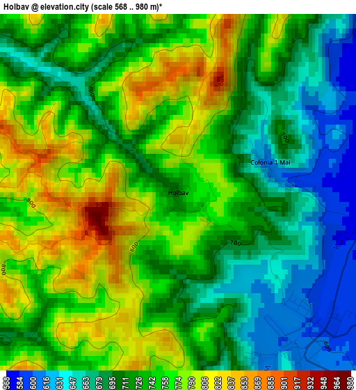
Below is the Elevation map of Holbav, which displays elevation range with different colors. Scale of the first map is from 568 to 980 m (1864 to 3215 ft) with average elevation of 732 meters (=2402 ft) [note 1]
These maps also provides idea of topography and contour of this city, they are displayed at different zoom levels. More info about maps, scale and edge coordinates you can find below images.
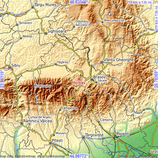
| \ | Map #1 | Topo.Map |
| Scale [m] | 568..980 m | × |
| Scale [ft] | 1864..3215 ft | × |
| Average | 732 m = 2402 ft | × |
| Width | 6.83 km = 4.2 mi | 218.6 km = 135.8 mi |
| Height | 6.83 km = 4.2 mi | 218.6 km = 135.8 mi |
| ↑Max Latitude | 45.689926° | 46.63346° |
| Latitude at center | 45.65922° | 45.65922° |
| ↓Min Latitude | 45.628497° | 44.66773° |
| ← Min Longitude | 25.343495° | 23.98119° |
| Longitude center | 25.38744° | 25.38744° |
| →Max Longitude | 25.431385° | 26.79369° |
Nearby cities:
Cities around Holbav sort by population:
• Zărnești elevation 716 m
12.2 km,  206°
206°
• Codlea 550 m
6.6 km,  46°
46°
• Râşnov 641 m
9.7 km,  150°
150°
• Vulcan 600 m
3.7 km,  141°
141°
• Bran 1017 m
16.1 km,  190°
190°
• Ghimbav 557 m
8.8 km,  84°
84°
• Dumbrăviţa 524 m
12.5 km,  16°
16°
• Cristian 603 m
7.8 km,  127°
127°
• Poiana Mărului (Brașov) 751 m
9.5 km,  225°
225°
• Sohodol 752 m
14.6 km,  175°
175°
• Șinca Nouă 539 m
11.9 km,  289°
289°
• Tohanu Nou 692 m
11.9 km, 180°
Multilingual:
 En español:
Holbav elevación 717 m.
 En France:
Holbav élévation 717 m.


Sources and notes:
- [note 1] Map square and city borders are not equal. Map elevation data is calculated only from area inside that square.
- [src 1] Elevation data from geonames database provided with same terms of usage.
- [src 2] The elevation map of Holbav is generated using elevation data from NASA's 3 arcsec (90m) resolution SRTM data.
- [src 3] Base (background) map © OpenStreetMap contributors tiles are generated by Geofabrik and OpenTopoMap.
Copyright & License:
This Holbav Elevation Map is licensed under CC BY-SA. You may reuse any part from this page, if you give a proper credit by linking to this URL:
 More info on terms of use page.