Hunedoara elevation
Hunedoara, Romania elevation is 236 meters and Hunedoara elevation in feet is 774 ft above sea level [src 1]. Hunedoara is a seat of a first-order administrative division (feature code) with elevation that is 16 meters (52 ft) smaller than average city elevation in Romania.
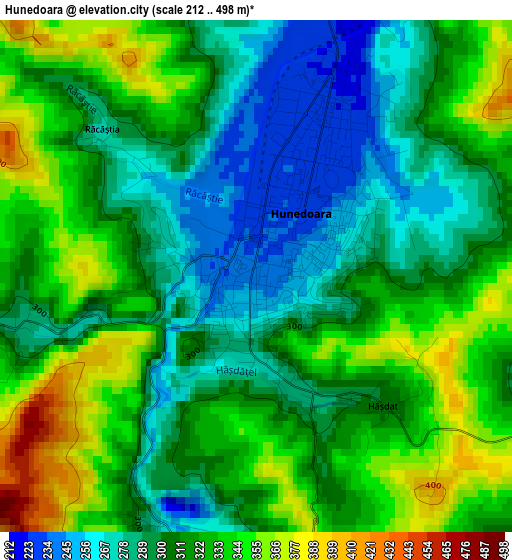
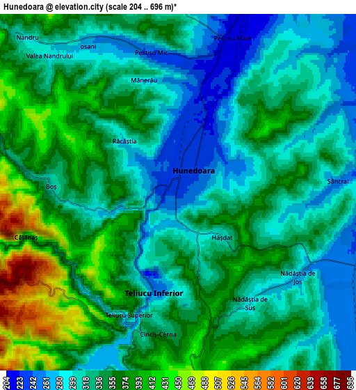
Below is the Elevation map of Hunedoara, which displays elevation range with different colors. Scale of the first map is from 212 to 498 m (696 to 1634 ft) with average elevation of 312.5 meters (=1025 ft) [note 1]
These maps also provides idea of topography and contour of this city, they are displayed at different zoom levels. More info about maps, scale and edge coordinates you can find below images.
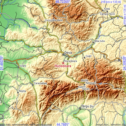
| \ | Map #1 | Map #2 | Topo.Map |
| Scale [m] | 212..498 m | 204..696 m | × |
| Scale [ft] | 696..1634 ft | 669..2283 ft | × |
| Average | 312.5 m = 1025 ft | 339 m = 1112 ft | × |
| Width | 6.82 km = 4.2 mi | 13.64 km = 8.5 mi | 218.2 km = 135.6 mi |
| Height | 6.82 km = 4.2 mi | 13.64 km = 8.5 mi | 218.2 km = 135.6 mi |
| ↑Max Latitude | 45.780656° | 45.811296° | 46.72265° |
| Latitude at center | 45.75° | 45.75° | 45.75° |
| ↓Min Latitude | 45.719327° | 45.688637° | 44.7601° |
| ← Min Longitude | 22.856055° | 22.812109° | 21.49375° |
| Longitude center | 22.9° | 22.9° | 22.9° |
| →Max Longitude | 22.943945° | 22.987891° | 24.30625° |
Nearby cities:
Cities around Hunedoara sort by population:
• Simeria elevation 200 m
14.3 km,  39°
39°
• Călan 245 m
6.7 km,  105°
105°
• Teliucu Inferior 300 m
3.9 km,  199°
199°
• Băcia 206 m
10.6 km,  58°
58°
• Ghelari 630 m
9.8 km,  247°
247°
• Cristur 202 m
9.4 km,  20°
20°
• Peștișu Mare 209 m
6.1 km, 19°
• Peştişu Mic 245 m
5.7 km,  346°
346°
• Topliţa 452 m
11.7 km,  230°
230°
• Cârjiţi 463 m
12.3 km,  335°
335°
• Cerbăl 746 m
14.7 km,  284°
284°
• Bretea Română 262 m
13.5 km,  137°
137°
Multilingual:
 En español:
Hunedoara elevación 236 m.
 En France:
Hunedoara élévation 236 m.
 Auf Deutsch:
Hunedoara höhe über dem Meeresspiegel ist 236 m.

Sources and notes:
- [note 1] Map square and city borders are not equal. Map elevation data is calculated only from area inside that square.
- [src 1] Elevation data from geonames database provided with same terms of usage.
- [src 2] The elevation map of Hunedoara is generated using elevation data from NASA's 3 arcsec (90m) resolution SRTM data.
- [src 3] Base (background) map © OpenStreetMap contributors tiles are generated by Geofabrik and OpenTopoMap.
Copyright & License:
This Hunedoara Elevation Map is licensed under CC BY-SA. You may reuse any part from this page, if you give a proper credit by linking to this URL:
 More info on terms of use page.