Iernut elevation
Iernut (Mureş, Oraş Iernut), Romania elevation is 275 meters and Iernut elevation in feet is 902 ft above sea level [src 1]. Iernut is a seat of a second-order administrative division (feature code) with elevation that is 23 meters (75 ft) bigger than average city elevation in Romania.
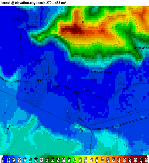
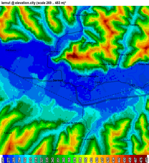
Below is the Elevation map of Iernut, which displays elevation range with different colors. Scale of the first map is from 270 to 483 m (886 to 1585 ft) with average elevation of 308 meters (=1010 ft) [note 1]
These maps also provides idea of topography and contour of this city, they are displayed at different zoom levels. More info about maps, scale and edge coordinates you can find below images.
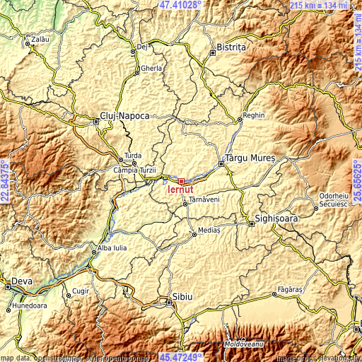
| \ | Map #1 | Map #2 | Topo.Map |
| Scale [m] | 270..483 m | 269..483 m | × |
| Scale [ft] | 886..1585 ft | 883..1585 ft | × |
| Average | 308 m = 1010 ft | 329.4 m = 1081 ft | × |
| Width | 6.73 km = 4.2 mi | 13.47 km = 8.4 mi | 215.5 km = 133.9 mi |
| Height | 6.73 km = 4.2 mi | 13.47 km = 8.4 mi | 215.4 km = 133.8 mi |
| ↑Max Latitude | 46.480269° | 46.510522° | 47.41028° |
| Latitude at center | 46.45° | 46.45° | 46.45° |
| ↓Min Latitude | 46.419714° | 46.389411° | 45.47249° |
| ← Min Longitude | 24.206055° | 24.162109° | 22.84375° |
| Longitude center | 24.25° | 24.25° | 24.25° |
| →Max Longitude | 24.293945° | 24.337891° | 25.65625° |
Nearby cities:
Cities around Iernut sort by population:
• Târnăveni elevation 284 m
13.6 km,  164°
164°
• Luduş 272 m
12.1 km,  287°
287°
• Sânpaul 284 m
7.7 km,  90°
90°
• Ogra 292 m
5.4 km,  109°
109°
• Iclănzel 310 m
9.6 km,  15°
15°
• Cuci 274 m
7.9 km,  283°
283°
• Cucerdea 330 m
5.7 km,  167°
167°
• Aţintiş 309 m
11.6 km,  260°
260°
• Bobohalma 362 m
11 km,  187°
187°
• Valea Izvoarelor 310 m
9.7 km,  97°
97°
• Cipău 281 m
2.1 km, 93°
• Papiu Ilarian 378 m
11.8 km,  341°
341°
Multilingual:
 En español:
Iernut elevación 275 m.
 En France:
Iernut élévation 275 m.


Sources and notes:
- [note 1] Map square and city borders are not equal. Map elevation data is calculated only from area inside that square.
- [src 1] Elevation data from geonames database provided with same terms of usage.
- [src 2] The elevation map of Iernut is generated using elevation data from NASA's 3 arcsec (90m) resolution SRTM data.
- [src 3] Base (background) map © OpenStreetMap contributors tiles are generated by Geofabrik and OpenTopoMap.
Copyright & License:
This Iernut Elevation Map is licensed under CC BY-SA. You may reuse any part from this page, if you give a proper credit by linking to this URL:
 More info on terms of use page.