Ieud elevation
Ieud (Maramureş, Comuna Ieud), Romania elevation is 422 meters and Ieud elevation in feet is 1385 ft above sea level [src 1]. Ieud is a seat of a second-order administrative division (feature code) with elevation that is 170 meters (558 ft) bigger than average city elevation in Romania.
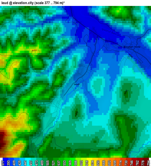
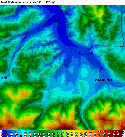
Below is the Elevation map of Ieud, which displays elevation range with different colors. Scale of the first map is from 377 to 794 m (1237 to 2605 ft) with average elevation of 480.4 meters (=1576 ft) [note 1]
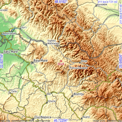
These maps also provides idea of topography and contour of this city, they are displayed at different zoom levels. More info about maps, scale and edge coordinates you can find below images.
| \ | Map #1 | Map #2 | Topo.Map |
| Scale [m] | 377..794 m | 355..1175 m | × |
| Scale [ft] | 1237..2605 ft | 1165..3855 ft | × |
| Average | 480.4 m = 1576 ft | 579 m = 1900 ft | × |
| Width | 6.58 km = 4.1 mi | 13.16 km = 8.2 mi | 210.6 km = 130.9 mi |
| Height | 6.58 km = 4.1 mi | 13.16 km = 8.2 mi | 210.5 km = 130.8 mi |
| ↑Max Latitude | 47.70754° | 47.737103° | 48.6162° |
| Latitude at center | 47.67796° | 47.67796° | 47.67796° |
| ↓Min Latitude | 47.648363° | 47.61875° | 46.72254° |
| ← Min Longitude | 24.190045° | 24.146099° | 22.82774° |
| Longitude center | 24.23399° | 24.23399° | 24.23399° |
| →Max Longitude | 24.277935° | 24.321881° | 25.64024° |
Nearby cities:
Cities around Ieud sort by population:
• Rozavlea elevation 360 m
6.3 km,  348°
348°
• Vişeu de Jos 457 m
11.2 km,  61°
61°
• Ruscova 419 m
13.3 km,  16°
16°
• Săliştea de Sus 498 m
9.2 km,  109°
109°
• Strâmtura 428 m
13.9 km,  327°
327°
• Bogdan Vodă 401 m
2.9 km, 57°
• Vișeu de Mijloc 474 m
13.6 km,  72°
72°
• Dragomireşti 434 m
4.4 km,  103°
103°
• Botiza 483 m
6.4 km,  258°
258°
• Șieu 371 m
5.2 km, 351°
• Leordina 402 m
11.8 km,  5°
5°
• Poienile Izei 507 m
9.1 km,  285°
285°
Multilingual:
 En español:
Ieud elevación 422 m.
 En France:
Ieud élévation 422 m.


Sources and notes:
- [note 1] Map square and city borders are not equal. Map elevation data is calculated only from area inside that square.
- [src 1] Elevation data from geonames database provided with same terms of usage.
- [src 2] The elevation map of Ieud is generated using elevation data from NASA's 3 arcsec (90m) resolution SRTM data.
- [src 3] Base (background) map © OpenStreetMap contributors tiles are generated by Geofabrik and OpenTopoMap.
Copyright & License:
This Ieud Elevation Map is licensed under CC BY-SA. You may reuse any part from this page, if you give a proper credit by linking to this URL:
 More info on terms of use page.