Strâmtura elevation
Strâmtura (Maramureş, Comuna Strâmtura), Romania elevation is 428 meters and Strâmtura elevation in feet is 1404 ft above sea level [src 1]. Strâmtura is a seat of a second-order administrative division (feature code) with elevation that is 176 meters (577 ft) bigger than average city elevation in Romania.
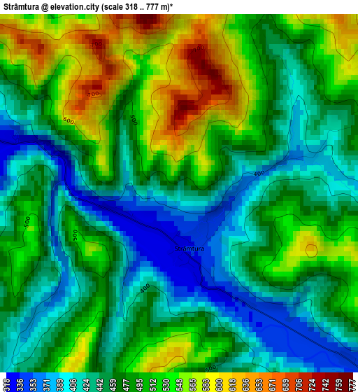
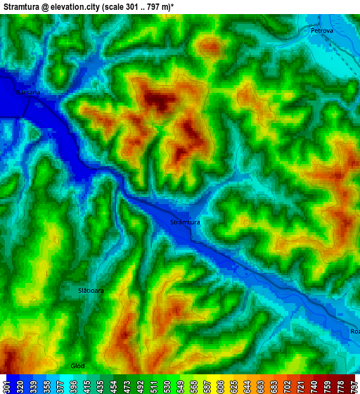
Below is the Elevation map of Strâmtura, which displays elevation range with different colors. Scale of the first map is from 318 to 777 m (1043 to 2549 ft) with average elevation of 480.7 meters (=1577 ft) [note 1]
These maps also provides idea of topography and contour of this city, they are displayed at different zoom levels. More info about maps, scale and edge coordinates you can find below images.
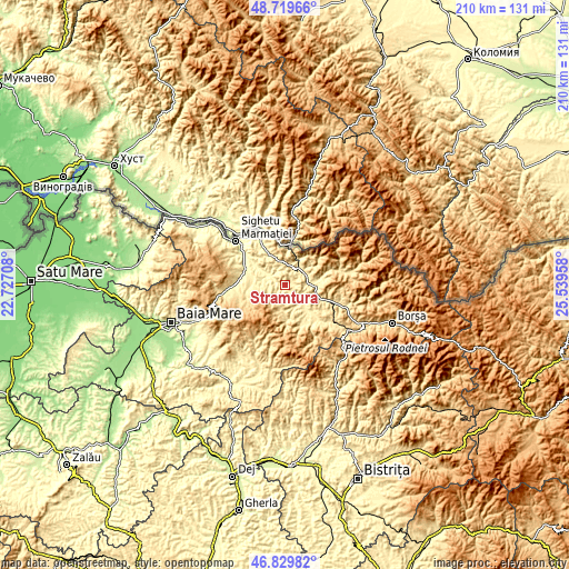
| \ | Map #1 | Map #2 | Topo.Map |
| Scale [m] | 318..777 m | 301..797 m | × |
| Scale [ft] | 1043..2549 ft | 988..2615 ft | × |
| Average | 480.7 m = 1577 ft | 486.5 m = 1596 ft | × |
| Width | 6.57 km = 4.1 mi | 13.13 km = 8.2 mi | 210.1 km = 130.5 mi |
| Height | 6.57 km = 4.1 mi | 13.13 km = 8.2 mi | 210.1 km = 130.5 mi |
| ↑Max Latitude | 47.81285° | 47.842353° | 48.71966° |
| Latitude at center | 47.78333° | 47.78333° | 47.78333° |
| ↓Min Latitude | 47.753793° | 47.72424° | 46.82982° |
| ← Min Longitude | 24.089385° | 24.045439° | 22.72708° |
| Longitude center | 24.13333° | 24.13333° | 24.13333° |
| →Max Longitude | 24.177275° | 24.221221° | 25.53958° |
Nearby cities:
Cities around Strâmtura sort by population:
• Bârsana elevation 344 m
6.2 km,  306°
306°
• Rozavlea 360 m
8.3 km,  131°
131°
• Ruscova 419 m
11.4 km,  84°
84°
• Bistra 383 m
10.5 km,  28°
28°
• Călineşti 387 m
12.2 km,  270°
270°
• Botiza 483 m
13 km,  174°
174°
• Petrova 379 m
8 km,  49°
49°
• Șieu 371 m
9.4 km, 133°
• Leordina 402 m
8.7 km,  90°
90°
• Crasna Vișeului 400 m
8.8 km,  55°
55°
• Văleni 399 m
8.8 km, 271°
• Poienile Izei 507 m
9.3 km,  187°
187°
Multilingual:
 En español:
Strâmtura elevación 428 m.
 En France:
Strâmtura élévation 428 m.
 Auf Deutsch:
Strâmtura höhe über dem Meeresspiegel ist 428 m.

Sources and notes:
- [note 1] Map square and city borders are not equal. Map elevation data is calculated only from area inside that square.
- [src 1] Elevation data from geonames database provided with same terms of usage.
- [src 2] The elevation map of Strâmtura is generated using elevation data from NASA's 3 arcsec (90m) resolution SRTM data.
- [src 3] Base (background) map © OpenStreetMap contributors tiles are generated by Geofabrik and OpenTopoMap.
Copyright & License:
This Strâmtura Elevation Map is licensed under CC BY-SA. You may reuse any part from this page, if you give a proper credit by linking to this URL:
 More info on terms of use page.