Călineşti elevation
Călineşti (Maramureş, Comuna Călineşti), Romania elevation is 387 meters and Călineşti elevation in feet is 1270 ft above sea level [src 1]. Călineşti is a seat of a second-order administrative division (feature code) with elevation that is 135 meters (443 ft) bigger than average city elevation in Romania.
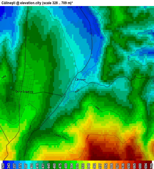
Below is the Elevation map of Călineşti, which displays elevation range with different colors. Scale of the first map is from 328 to 709 m (1076 to 2326 ft) with average elevation of 465.6 meters (=1528 ft) [note 1]
These maps also provides idea of topography and contour of this city, they are displayed at different zoom levels. More info about maps, scale and edge coordinates you can find below images.
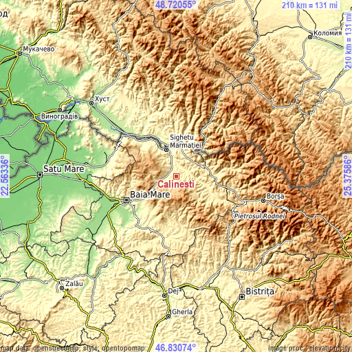
| \ | Map #1 | Topo.Map |
| Scale [m] | 328..709 m | × |
| Scale [ft] | 1076..2326 ft | × |
| Average | 465.6 m = 1528 ft | × |
| Width | 6.57 km = 4.1 mi | 210.1 km = 130.5 mi |
| Height | 6.57 km = 4.1 mi | 210.1 km = 130.5 mi |
| ↑Max Latitude | 47.81375° | 48.72055° |
| Latitude at center | 47.78423° | 47.78423° |
| ↓Min Latitude | 47.754694° | 46.83074° |
| ← Min Longitude | 23.925665° | 22.56336° |
| Longitude center | 23.96961° | 23.96961° |
| →Max Longitude | 24.013555° | 25.37586° |
Nearby cities:
Cities around Călineşti sort by population:
• Bârsana elevation 344 m
8.1 km,  63°
63°
• Ocna Şugatag 455 m
2.7 km,  267°
267°
• Budeşti 601 m
5.8 km,  194°
194°
• Giuleşti 355 m
4.5 km,  323°
323°
• Deseşti 444 m
9.1 km,  257°
257°
• Berbești 301 m
7.6 km,  339°
339°
• Oncești 290 m
7.2 km,  7°
7°
• Văleni 399 m
3.5 km,  87°
87°
• Breb 501 m
6.3 km,  230°
230°
• Sat-Șugatag 369 m
5 km,  287°
287°
• Mara 461 m
10.8 km,  252°
252°
• Sârbi 477 m
3.1 km,  216°
216°
Multilingual:
 En español:
Călineşti elevación 387 m.
 En France:
Călineşti élévation 387 m.
 Auf Deutsch:
Călineşti höhe über dem Meeresspiegel ist 387 m.

Sources and notes:
- [note 1] Map square and city borders are not equal. Map elevation data is calculated only from area inside that square.
- [src 1] Elevation data from geonames database provided with same terms of usage.
- [src 2] The elevation map of Călineşti is generated using elevation data from NASA's 3 arcsec (90m) resolution SRTM data.
- [src 3] Base (background) map © OpenStreetMap contributors tiles are generated by Geofabrik and OpenTopoMap.
Copyright & License:
This Călineşti Elevation Map is licensed under CC BY-SA. You may reuse any part from this page, if you give a proper credit by linking to this URL:
 More info on terms of use page.