Întorsura elevation
Întorsura (Dolj, Comuna Întorsura), Romania elevation is 81 meters and Întorsura elevation in feet is 266 ft above sea level [src 1]. Întorsura is a seat of a second-order administrative division (feature code) with elevation that is 171 meters (561 ft) smaller than average city elevation in Romania.
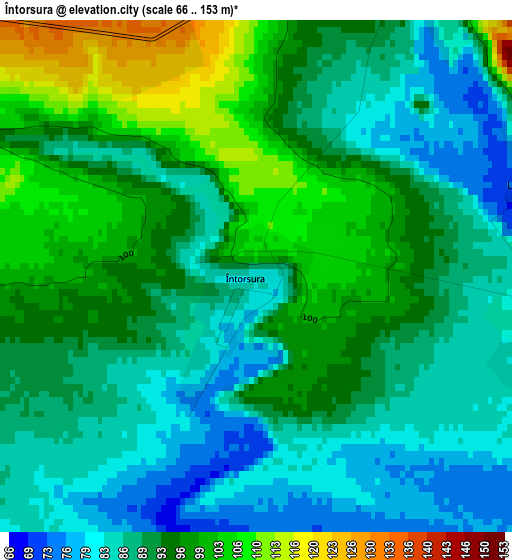
Below is the Elevation map of Întorsura, which displays elevation range with different colors. Scale of the first map is from 66 to 153 m (217 to 502 ft) with average elevation of 92.1 meters (=302 ft) [note 1]
These maps also provides idea of topography and contour of this city, they are displayed at different zoom levels. More info about maps, scale and edge coordinates you can find below images.
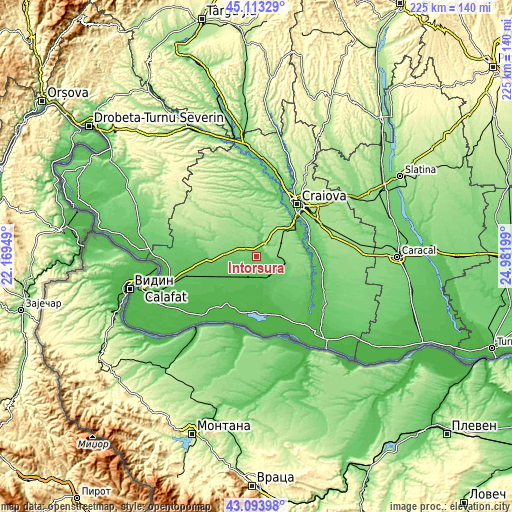
| \ | Map #1 | Topo.Map |
| Scale [m] | 66..153 m | × |
| Scale [ft] | 217..502 ft | × |
| Average | 92.1 m = 302 ft | × |
| Width | 7.02 km = 4.4 mi | 224.5 km = 139.5 mi |
| Height | 7.02 km = 4.4 mi | 224.5 km = 139.5 mi |
| ↑Max Latitude | 44.143803° | 45.11329° |
| Latitude at center | 44.11226° | 44.11226° |
| ↓Min Latitude | 44.0807° | 43.09398° |
| ← Min Longitude | 23.531795° | 22.16949° |
| Longitude center | 23.57574° | 23.57574° |
| →Max Longitude | 23.619685° | 24.98199° |
Nearby cities:
Cities around Întorsura sort by population:
• Segarcea elevation 146 m
14 km,  95°
95°
• Cerăt 62 m
8.9 km,  124°
124°
• Giubega 117 m
13.5 km,  277°
277°
• Giurgiţa 63 m
11.6 km,  156°
156°
• Lipovu 69 m
4.8 km,  106°
106°
• Urzicuţa 54 m
10.8 km,  190°
190°
• Siliştea Crucii 52 m
11.5 km,  220°
220°
• Perișor 119 m
8.7 km,  293°
293°
• Radovan 93 m
6.9 km,  28°
28°
• Sălcuța 148 m
11.4 km,  62°
62°
• Cioroiași 72 m
10.5 km,  252°
252°
• Galiciuica 93 m
14.8 km,  266°
266°
Multilingual:
 En español:
Întorsura elevación 81 m.
 En France:
Întorsura élévation 81 m.
 Auf Deutsch:
Întorsura höhe über dem Meeresspiegel ist 81 m.

Sources and notes:
- [note 1] Map square and city borders are not equal. Map elevation data is calculated only from area inside that square.
- [src 1] Elevation data from geonames database provided with same terms of usage.
- [src 2] The elevation map of Întorsura is generated using elevation data from NASA's 3 arcsec (90m) resolution SRTM data.
- [src 3] Base (background) map © OpenStreetMap contributors tiles are generated by Geofabrik and OpenTopoMap.
Copyright & License:
This Întorsura Elevation Map is licensed under CC BY-SA. You may reuse any part from this page, if you give a proper credit by linking to this URL:
 More info on terms of use page.