Ion Corvin elevation
Ion Corvin (Constanța, Comuna Ion Corvin), Romania elevation is 139 meters and Ion Corvin elevation in feet is 456 ft above sea level [src 1]. Ion Corvin is a seat of a second-order administrative division (feature code) with elevation that is 113 meters (371 ft) smaller than average city elevation in Romania.
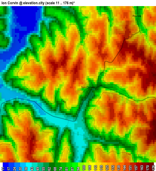
Below is the Elevation map of Ion Corvin, which displays elevation range with different colors. Scale of the first map is from 11 to 176 m (36 to 577 ft) with average elevation of 102.2 meters (=335 ft) [note 1]
These maps also provides idea of topography and contour of this city, they are displayed at different zoom levels. More info about maps, scale and edge coordinates you can find below images.
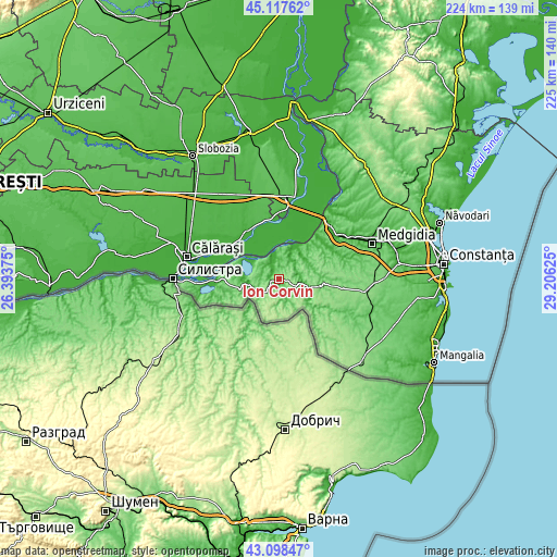
| \ | Map #1 | Topo.Map |
| Scale [m] | 11..176 m | × |
| Scale [ft] | 36..577 ft | × |
| Average | 102.2 m = 335 ft | × |
| Width | 7.02 km = 4.4 mi | 224.5 km = 139.5 mi |
| Height | 7.02 km = 4.4 mi | 224.5 km = 139.5 mi |
| ↑Max Latitude | 44.148211° | 45.11762° |
| Latitude at center | 44.11667° | 44.11667° |
| ↓Min Latitude | 44.085112° | 43.09847° |
| ← Min Longitude | 27.756055° | 26.39375° |
| Longitude center | 27.8° | 27.8° |
| →Max Longitude | 27.843945° | 29.20625° |
Nearby cities:
Cities around Ion Corvin sort by population:
• Băneasa elevation 110 m
9.7 km,  235°
235°
• Rasova 30 m
18 km,  36°
36°
• Lipniţa 101 m
16.1 km,  263°
263°
• Oltina 18 m
12 km,  297°
297°
• Aliman 63 m
8.4 km,  28°
28°
• Unirea 10 m
21.3 km,  321°
321°
• Dobromir 102 m
11.2 km,  186°
186°
• Deleni 118 m
17.4 km,  96°
96°
• Adamclisi 103 m
12.5 km,  107°
107°
• Dunăreni 57 m
9.8 km,  355°
355°
• Pietreni 91 m
21.5 km, 96°
• Viile 22 m
6.1 km,  326°
326°
Multilingual:
 En español:
Ion Corvin elevación 139 m.
 En France:
Ion Corvin élévation 139 m.
 Auf Deutsch:
Ion Corvin höhe über dem Meeresspiegel ist 139 m.

Sources and notes:
- [note 1] Map square and city borders are not equal. Map elevation data is calculated only from area inside that square.
- [src 1] Elevation data from geonames database provided with same terms of usage.
- [src 2] The elevation map of Ion Corvin is generated using elevation data from NASA's 3 arcsec (90m) resolution SRTM data.
- [src 3] Base (background) map © OpenStreetMap contributors tiles are generated by Geofabrik and OpenTopoMap.
Copyright & License:
This Ion Corvin Elevation Map is licensed under CC BY-SA. You may reuse any part from this page, if you give a proper credit by linking to this URL:
 More info on terms of use page.