Măstăcani elevation
Măstăcani (Galaţi, Comuna Măstăcani), Romania elevation is 35 meters and Măstăcani elevation in feet is 115 ft above sea level [src 1]. Măstăcani is a seat of a second-order administrative division (feature code) with elevation that is 217 meters (712 ft) smaller than average city elevation in Romania.
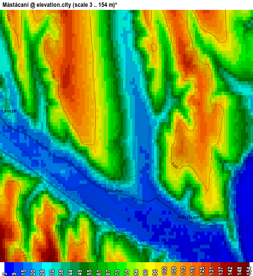
Below is the Elevation map of Măstăcani, which displays elevation range with different colors. Scale of the first map is from 3 to 154 m (10 to 505 ft) with average elevation of 63.3 meters (=208 ft) [note 1]
These maps also provides idea of topography and contour of this city, they are displayed at different zoom levels. More info about maps, scale and edge coordinates you can find below images.
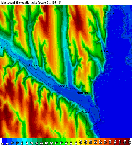
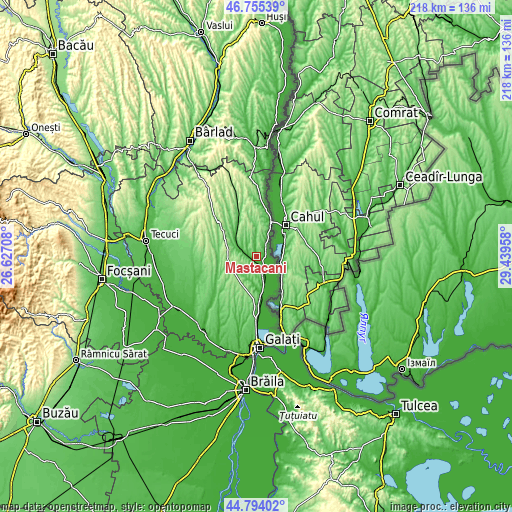
| \ | Map #1 | Map #2 | Topo.Map |
| Scale [m] | 3..154 m | 0..165 m | × |
| Scale [ft] | 10..505 ft | 0..541 ft | × |
| Average | 63.3 m = 208 ft | 66.4 m = 218 ft | × |
| Width | 6.82 km = 4.2 mi | 13.63 km = 8.5 mi | 218.1 km = 135.5 mi |
| Height | 6.82 km = 4.2 mi | 13.63 km = 8.5 mi | 218.1 km = 135.5 mi |
| ↑Max Latitude | 45.813968° | 45.844589° | 46.75539° |
| Latitude at center | 45.78333° | 45.78333° | 45.78333° |
| ↓Min Latitude | 45.752675° | 45.722004° | 44.79402° |
| ← Min Longitude | 27.989385° | 27.945439° | 26.62708° |
| Longitude center | 28.03333° | 28.03333° | 28.03333° |
| →Max Longitude | 28.077275° | 28.121221° | 29.43958° |
Nearby cities:
Cities around Măstăcani sort by population:
• Frumuşiţa elevation 19 m
13.2 km,  168°
168°
• Târgu Bujor 137 m
13.9 km,  311°
311°
• Folteşti 35 m
3.9 km,  160°
160°
• Cuca 164 m
12.9 km,  244°
244°
• Chiraftei 52 m
1.3 km,  201°
201°
• Vlădeşti 54 m
8.4 km,  27°
27°
• Fântânele 118 m
9.4 km,  194°
194°
• Viile 24 m
7.2 km,  291°
291°
• Moscu 50 m
15.4 km,  329°
329°
• Umbrărești 33 m
11.5 km, 309°
• Scânteiești 120 m
11.8 km, 199°
• Fârţăneşti 54 m
5.4 km, 313°
Multilingual:
 En español:
Măstăcani elevación 35 m.
 En France:
Măstăcani élévation 35 m.
 Auf Deutsch:
Măstăcani höhe über dem Meeresspiegel ist 35 m.

Sources and notes:
- [note 1] Map square and city borders are not equal. Map elevation data is calculated only from area inside that square.
- [src 1] Elevation data from geonames database provided with same terms of usage.
- [src 2] The elevation map of Măstăcani is generated using elevation data from NASA's 3 arcsec (90m) resolution SRTM data.
- [src 3] Base (background) map © OpenStreetMap contributors tiles are generated by Geofabrik and OpenTopoMap.
Copyright & License:
This Măstăcani Elevation Map is licensed under CC BY-SA. You may reuse any part from this page, if you give a proper credit by linking to this URL:
 More info on terms of use page.