Mihăileni elevation
Mihăileni (Sibiu, Comuna Mihăileni), Romania elevation is 455 meters and Mihăileni elevation in feet is 1493 ft above sea level [src 1]. Mihăileni is a seat of a second-order administrative division (feature code) with elevation that is 203 meters (666 ft) bigger than average city elevation in Romania.
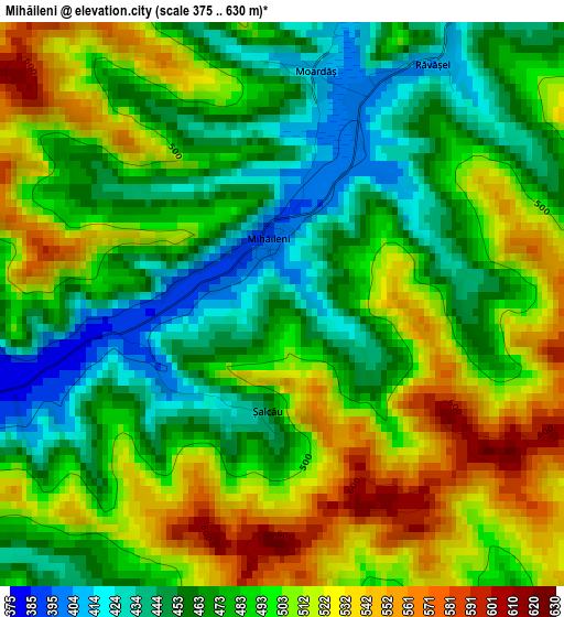
Below is the Elevation map of Mihăileni, which displays elevation range with different colors. Scale of the first map is from 375 to 630 m (1230 to 2067 ft) with average elevation of 488.7 meters (=1603 ft) [note 1]
These maps also provides idea of topography and contour of this city, they are displayed at different zoom levels. More info about maps, scale and edge coordinates you can find below images.
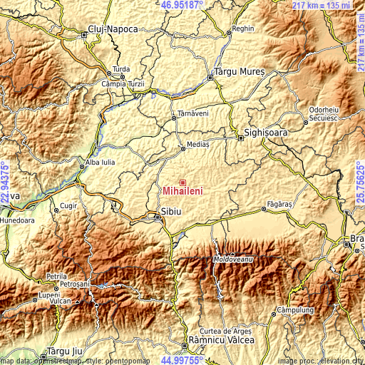
| \ | Map #1 | Topo.Map |
| Scale [m] | 375..630 m | × |
| Scale [ft] | 1230..2067 ft | × |
| Average | 488.7 m = 1603 ft | × |
| Width | 6.79 km = 4.2 mi | 217.3 km = 135 mi |
| Height | 6.79 km = 4.2 mi | 217.3 km = 135 mi |
| ↑Max Latitude | 46.013858° | 46.95187° |
| Latitude at center | 45.98333° | 45.98333° |
| ↓Min Latitude | 45.952785° | 44.99755° |
| ← Min Longitude | 24.306055° | 22.94375° |
| Longitude center | 24.35° | 24.35° |
| →Max Longitude | 24.393945° | 25.75625° |
Nearby cities:
Cities around Mihăileni sort by population:
• Copşa Mică elevation 281 m
16.7 km,  332°
332°
• Şeíca Mare 399 m
15.9 km,  283°
283°
• Axente Sever 283 m
16.6 km,  321°
321°
• Slimnic 489 m
16 km,  242°
242°
• Moşna 424 m
11.8 km,  19°
19°
• Nocrich 451 m
12.1 km,  140°
140°
• Vurpăr 478 m
9.3 km,  180°
180°
• Valea Viilor 334 m
12.3 km,  335°
335°
• Agârbiciu 314 m
15.3 km,  307°
307°
• Ighișu Nou 342 m
14.2 km,  359°
359°
• Alțâna 417 m
10.6 km,  121°
121°
• Bârghiş 453 m
14.2 km,  90°
90°
Multilingual:
 En español:
Mihăileni elevación 455 m.
 En France:
Mihăileni élévation 455 m.
 Auf Deutsch:
Mihăileni höhe über dem Meeresspiegel ist 455 m.

Sources and notes:
- [note 1] Map square and city borders are not equal. Map elevation data is calculated only from area inside that square.
- [src 1] Elevation data from geonames database provided with same terms of usage.
- [src 2] The elevation map of Mihăileni is generated using elevation data from NASA's 3 arcsec (90m) resolution SRTM data.
- [src 3] Base (background) map © OpenStreetMap contributors tiles are generated by Geofabrik and OpenTopoMap.
Copyright & License:
This Mihăileni Elevation Map is licensed under CC BY-SA. You may reuse any part from this page, if you give a proper credit by linking to this URL:
 More info on terms of use page.