Valea Viilor elevation
Valea Viilor (Sibiu, Comuna Valea Viilor), Romania elevation is 334 meters and Valea Viilor elevation in feet is 1096 ft above sea level [src 1]. Valea Viilor is a seat of a second-order administrative division (feature code) with elevation that is 82 meters (269 ft) bigger than average city elevation in Romania.
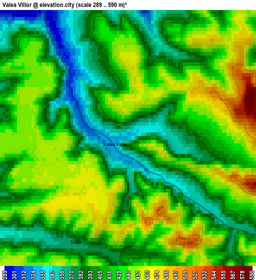
Below is the Elevation map of Valea Viilor, which displays elevation range with different colors. Scale of the first map is from 289 to 590 m (948 to 1936 ft) with average elevation of 417.7 meters (=1370 ft) [note 1]
These maps also provides idea of topography and contour of this city, they are displayed at different zoom levels. More info about maps, scale and edge coordinates you can find below images.
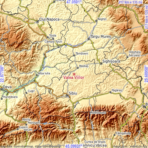
| \ | Map #1 | Topo.Map |
| Scale [m] | 289..590 m | × |
| Scale [ft] | 948..1936 ft | × |
| Average | 417.7 m = 1370 ft | × |
| Width | 6.78 km = 4.2 mi | 216.9 km = 134.8 mi |
| Height | 6.78 km = 4.2 mi | 216.9 km = 134.8 mi |
| ↑Max Latitude | 46.113803° | 47.0501° |
| Latitude at center | 46.08333° | 46.08333° |
| ↓Min Latitude | 46.052841° | 45.09931° |
| ← Min Longitude | 24.239385° | 22.87708° |
| Longitude center | 24.28333° | 24.28333° |
| →Max Longitude | 24.327275° | 25.68958° |
Nearby cities:
Cities around Valea Viilor sort by population:
• Mediaş elevation 301 m
10.6 km,  29°
29°
• Copşa Mică 281 m
4.5 km,  325°
325°
• Şeíca Mare 399 m
12.7 km,  234°
234°
• Axente Sever 283 m
5.5 km,  289°
289°
• Bazna 304 m
13 km,  0°
0°
• Moşna 424 m
9 km,  90°
90°
• Micăsasa 269 m
12.9 km,  270°
270°
• Şeica Mică 366 m
12.2 km,  252°
252°
• Agârbiciu 314 m
7.1 km,  255°
255°
• Târnava 290 m
6.3 km, 4°
• Ighișu Nou 342 m
6 km,  58°
58°
• Mihăileni 455 m
12.3 km,  155°
155°
Multilingual:
 En español:
Valea Viilor elevación 334 m.
 En France:
Valea Viilor élévation 334 m.
 Auf Deutsch:
Valea Viilor höhe über dem Meeresspiegel ist 334 m.

Sources and notes:
- [note 1] Map square and city borders are not equal. Map elevation data is calculated only from area inside that square.
- [src 1] Elevation data from geonames database provided with same terms of usage.
- [src 2] The elevation map of Valea Viilor is generated using elevation data from NASA's 3 arcsec (90m) resolution SRTM data.
- [src 3] Base (background) map © OpenStreetMap contributors tiles are generated by Geofabrik and OpenTopoMap.
Copyright & License:
This Valea Viilor Elevation Map is licensed under CC BY-SA. You may reuse any part from this page, if you give a proper credit by linking to this URL:
 More info on terms of use page.