Movileni elevation
Movileni (Olt, Comuna Movileni), Romania elevation is 160 meters and Movileni elevation in feet is 525 ft above sea level [src 1]. Movileni is a seat of a second-order administrative division (feature code) with elevation that is 92 meters (302 ft) smaller than average city elevation in Romania.
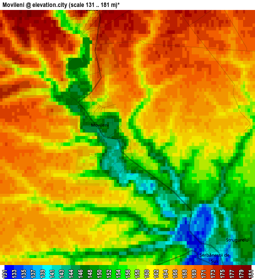
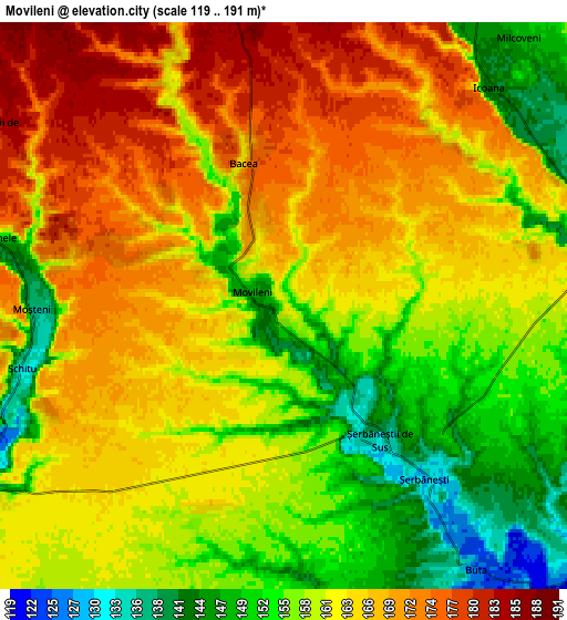
Below is the Elevation map of Movileni, which displays elevation range with different colors. Scale of the first map is from 131 to 181 m (430 to 594 ft) with average elevation of 161 meters (=528 ft) [note 1]
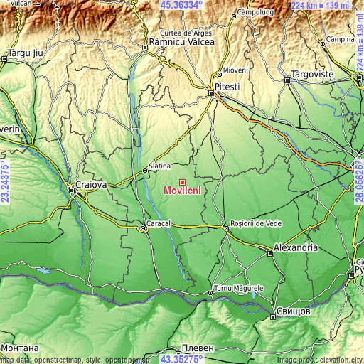
These maps also provides idea of topography and contour of this city, they are displayed at different zoom levels. More info about maps, scale and edge coordinates you can find below images.
| \ | Map #1 | Map #2 | Topo.Map |
| Scale [m] | 131..181 m | 119..191 m | × |
| Scale [ft] | 430..594 ft | 390..627 ft | × |
| Average | 161 m = 528 ft | 161.7 m = 531 ft | × |
| Width | 6.99 km = 4.3 mi | 13.97 km = 8.7 mi | 223.6 km = 138.9 mi |
| Height | 6.99 km = 4.3 mi | 13.97 km = 8.7 mi | 223.5 km = 138.9 mi |
| ↑Max Latitude | 44.398077° | 44.429468° | 45.36334° |
| Latitude at center | 44.36667° | 44.36667° | 44.36667° |
| ↓Min Latitude | 44.335246° | 44.303805° | 43.35275° |
| ← Min Longitude | 24.606055° | 24.562109° | 23.24375° |
| Longitude center | 24.65° | 24.65° | 24.65° |
| →Max Longitude | 24.693945° | 24.737891° | 26.05625° |
Nearby cities:
Cities around Movileni sort by population:
• Perieţi elevation 181 m
8.8 km,  295°
295°
• Ghioca 131 m
8.6 km,  129°
129°
• Tufeni 134 m
10.6 km,  90°
90°
• Crâmpoia 124 m
10.4 km, 133°
• Şerbăneşti 141 m
5.4 km, 132°
• Schitu 136 m
6.9 km,  254°
254°
• Barza 126 m
11.2 km,  109°
109°
• Icoana 144 m
7.7 km,  43°
43°
• Bacea 162 m
3.6 km,  344°
344°
• Greci 129 m
8.3 km,  240°
240°
• Catanele 151 m
7.2 km,  283°
283°
• Sinești 156 m
11.3 km,  6°
6°
Multilingual:
 En español:
Movileni elevación 160 m.
 En France:
Movileni élévation 160 m.
 Auf Deutsch:
Movileni höhe über dem Meeresspiegel ist 160 m.

Sources and notes:
- [note 1] Map square and city borders are not equal. Map elevation data is calculated only from area inside that square.
- [src 1] Elevation data from geonames database provided with same terms of usage.
- [src 2] The elevation map of Movileni is generated using elevation data from NASA's 3 arcsec (90m) resolution SRTM data.
- [src 3] Base (background) map © OpenStreetMap contributors tiles are generated by Geofabrik and OpenTopoMap.
Copyright & License:
This Movileni Elevation Map is licensed under CC BY-SA. You may reuse any part from this page, if you give a proper credit by linking to this URL:
 More info on terms of use page.