Păuleşti elevation
Păuleşti (Prahova, Comuna Păuleşti), Romania elevation is 210 meters and Păuleşti elevation in feet is 689 ft above sea level [src 1]. Păuleşti is a seat of a second-order administrative division (feature code) with elevation that is 42 meters (138 ft) smaller than average city elevation in Romania.
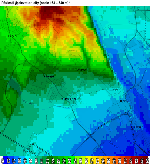
Below is the Elevation map of Păuleşti, which displays elevation range with different colors. Scale of the first map is from 163 to 340 m (535 to 1115 ft) with average elevation of 213.9 meters (=702 ft) [note 1]
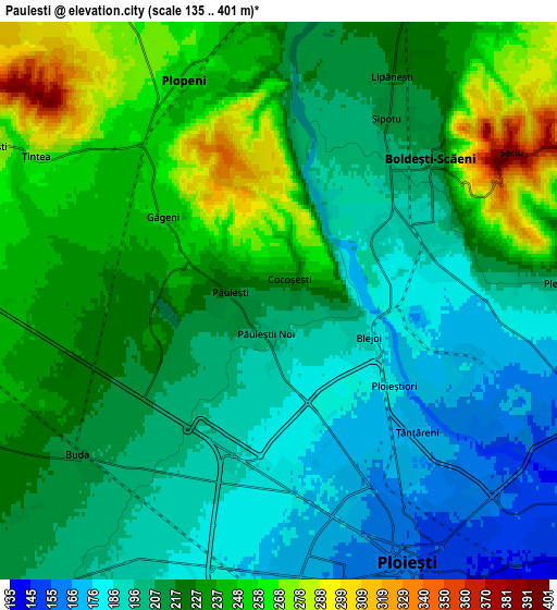
These maps also provides idea of topography and contour of this city, they are displayed at different zoom levels. More info about maps, scale and edge coordinates you can find below images.

| \ | Map #1 | Map #2 | Topo.Map |
| Scale [m] | 163..340 m | 135..401 m | × |
| Scale [ft] | 535..1115 ft | 443..1316 ft | × |
| Average | 213.9 m = 702 ft | 219 m = 719 ft | × |
| Width | 6.91 km = 4.3 mi | 13.82 km = 8.6 mi | 221.1 km = 137.4 mi |
| Height | 6.91 km = 4.3 mi | 13.82 km = 8.6 mi | 221.1 km = 137.4 mi |
| ↑Max Latitude | 45.031066° | 45.062114° | 45.98574° |
| Latitude at center | 45° | 45° | 45° |
| ↓Min Latitude | 44.968918° | 44.937818° | 43.997° |
| ← Min Longitude | 25.939385° | 25.895439° | 24.57708° |
| Longitude center | 25.98333° | 25.98333° | 25.98333° |
| →Max Longitude | 26.027275° | 26.071221° | 27.38958° |
Nearby cities:
Cities around Păuleşti sort by population:
• Ploieşti elevation 161 m
6.1 km,  154°
154°
• Boldeşti-Scăeni 211 m
5.4 km,  46°
46°
• Plopeni 254 m
6 km,  335°
335°
• Blejoi 182 m
2.6 km,  90°
90°
• Lipăneşti 217 m
6.1 km,  25°
25°
• Pleașa 208 m
7 km,  84°
84°
• Țintea 275 m
7.3 km,  301°
301°
• Ploieștiori 180 m
3.4 km,  126°
126°
• Șipotu 210 m
5.3 km, 30°
• Găgeni 249 m
3.8 km,  309°
309°
• Plopeni 229 m
7.3 km,  358°
358°
• Seciu 363 m
7.4 km,  60°
60°
Multilingual:
 En español:
Păuleşti elevación 210 m.
 En France:
Păuleşti élévation 210 m.
 Auf Deutsch:
Păuleşti höhe über dem Meeresspiegel ist 210 m.

Sources and notes:
- [note 1] Map square and city borders are not equal. Map elevation data is calculated only from area inside that square.
- [src 1] Elevation data from geonames database provided with same terms of usage.
- [src 2] The elevation map of Păuleşti is generated using elevation data from NASA's 3 arcsec (90m) resolution SRTM data.
- [src 3] Base (background) map © OpenStreetMap contributors tiles are generated by Geofabrik and OpenTopoMap.
Copyright & License:
This Păuleşti Elevation Map is licensed under CC BY-SA. You may reuse any part from this page, if you give a proper credit by linking to this URL:
 More info on terms of use page.