Ploieşti elevation
Ploieşti (Prahova, Municipiul Ploieşti), Romania elevation is 161 meters and Ploieşti elevation in feet is 528 ft above sea level [src 1]. Ploieşti is a seat of a first-order administrative division (feature code) with elevation that is 91 meters (299 ft) smaller than average city elevation in Romania.
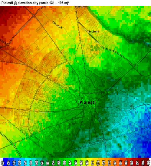
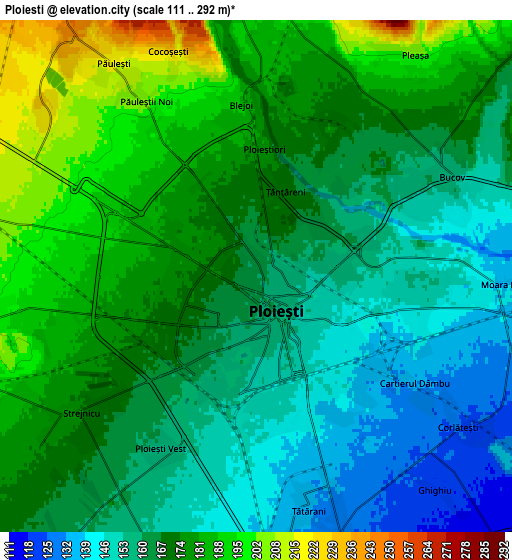
Below is the Elevation map of Ploieşti, which displays elevation range with different colors. Scale of the first map is from 131 to 196 m (430 to 643 ft) with average elevation of 162.6 meters (=533 ft) [note 1]
These maps also provides idea of topography and contour of this city, they are displayed at different zoom levels. More info about maps, scale and edge coordinates you can find below images.
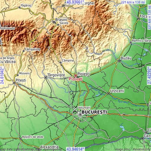
| \ | Map #1 | Map #2 | Topo.Map |
| Scale [m] | 131..196 m | 111..292 m | × |
| Scale [ft] | 430..643 ft | 364..958 ft | × |
| Average | 162.6 m = 533 ft | 167.7 m = 550 ft | × |
| Width | 6.92 km = 4.3 mi | 13.83 km = 8.6 mi | 221.3 km = 137.5 mi |
| Height | 6.92 km = 4.3 mi | 13.83 km = 8.6 mi | 221.3 km = 137.5 mi |
| ↑Max Latitude | 44.981093° | 45.012169° | 45.93661° |
| Latitude at center | 44.95° | 44.95° | 44.95° |
| ↓Min Latitude | 44.91889° | 44.887764° | 43.94614° |
| ← Min Longitude | 25.972725° | 25.928779° | 24.61042° |
| Longitude center | 26.01667° | 26.01667° | 26.01667° |
| →Max Longitude | 26.060615° | 26.104561° | 27.42292° |
Nearby cities:
Cities around Ploieşti sort by population:
• Bucov elevation 142 m
5.6 km,  70°
70°
• Bărcăneşti 129 m
7.9 km,  160°
160°
• Blejoi 182 m
5.6 km,  0°
0°
• Berceni 129 m
8.1 km,  103°
103°
• Păuleşti 210 m
6.1 km,  334°
334°
• Strejnicu 177 m
6.3 km,  234°
234°
• Pleașa 208 m
7.6 km,  35°
35°
• Tătărani 133 m
6 km,  166°
166°
• Ploieștiori 180 m
3.5 km, 1°
• Corlătești 124 m
6.9 km,  126°
126°
• Rachieri 139 m
8.8 km,  86°
86°
• Chițorani 190 m
8.5 km, 71°
Multilingual:
 En español:
Ploieşti elevación 161 m.
 En France:
Ploieşti élévation 161 m.
 Auf Deutsch:
Ploieşti höhe über dem Meeresspiegel ist 161 m.

Sources and notes:
- [note 1] Map square and city borders are not equal. Map elevation data is calculated only from area inside that square.
- [src 1] Elevation data from geonames database provided with same terms of usage.
- [src 2] The elevation map of Ploieşti is generated using elevation data from NASA's 3 arcsec (90m) resolution SRTM data.
- [src 3] Base (background) map © OpenStreetMap contributors tiles are generated by Geofabrik and OpenTopoMap.
Copyright & License:
This Ploieşti Elevation Map is licensed under CC BY-SA. You may reuse any part from this page, if you give a proper credit by linking to this URL:
 More info on terms of use page.