Peştera elevation
Peştera (Constanța, Comuna Peştera), Romania elevation is 75 meters and Peştera elevation in feet is 246 ft above sea level [src 1]. Peştera is a seat of a second-order administrative division (feature code) with elevation that is 177 meters (581 ft) smaller than average city elevation in Romania.
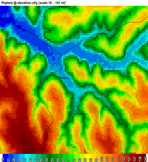
Below is the Elevation map of Peştera, which displays elevation range with different colors. Scale of the first map is from 16 to 141 m (52 to 463 ft) with average elevation of 80.2 meters (=263 ft) [note 1]
These maps also provides idea of topography and contour of this city, they are displayed at different zoom levels. More info about maps, scale and edge coordinates you can find below images.
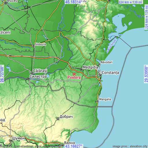
| \ | Map #1 | Topo.Map |
| Scale [m] | 16..141 m | × |
| Scale [ft] | 52..463 ft | × |
| Average | 80.2 m = 263 ft | × |
| Width | 7.01 km = 4.4 mi | 224.3 km = 139.4 mi |
| Height | 7.01 km = 4.4 mi | 224.2 km = 139.3 mi |
| ↑Max Latitude | 44.214835° | 45.18314° |
| Latitude at center | 44.18333° | 44.18333° |
| ↓Min Latitude | 44.151808° | 43.16627° |
| ← Min Longitude | 28.089385° | 26.72708° |
| Longitude center | 28.13333° | 28.13333° |
| →Max Longitude | 28.177275° | 29.53958° |
Nearby cities:
Cities around Peştera sort by population:
• Medgidia elevation 9 m
14.1 km,  58°
58°
• Cobadin 129 m
13 km,  149°
149°
• Mircea Vodă 45 m
11.4 km,  13°
13°
• Rasova 30 m
17.3 km,  293°
293°
• Ciocârlia 130 m
15.1 km,  127°
127°
• Deleni 118 m
13.1 km,  225°
225°
• Satu Nou 27 m
12.1 km,  37°
37°
• Viișoara 136 m
12.7 km,  157°
157°
• Valea Dacilor 105 m
14.8 km,  84°
84°
• Făclia 32 m
11 km,  348°
348°
• Pietreni 91 m
11 km,  208°
208°
• Saligny 38 m
11.4 km,  342°
342°
Multilingual:
 En español:
Peştera elevación 75 m.
 En France:
Peştera élévation 75 m.


Sources and notes:
- [note 1] Map square and city borders are not equal. Map elevation data is calculated only from area inside that square.
- [src 1] Elevation data from geonames database provided with same terms of usage.
- [src 2] The elevation map of Peştera is generated using elevation data from NASA's 3 arcsec (90m) resolution SRTM data.
- [src 3] Base (background) map © OpenStreetMap contributors tiles are generated by Geofabrik and OpenTopoMap.
Copyright & License:
This Peştera Elevation Map is licensed under CC BY-SA. You may reuse any part from this page, if you give a proper credit by linking to this URL:
 More info on terms of use page.