Petreştii de Jos elevation
Petreştii de Jos (Cluj, Comuna Petreştii De Jos), Romania elevation is 471 meters and Petreştii de Jos elevation in feet is 1545 ft above sea level [src 1]. Petreştii de Jos is a populated place (feature code) with elevation that is 219 meters (719 ft) bigger than average city elevation in Romania.
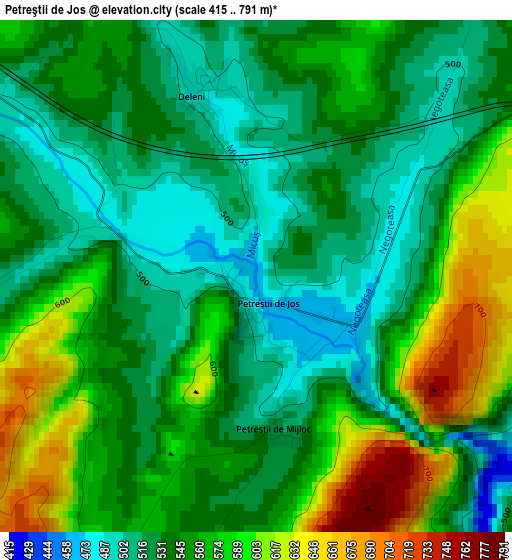
Below is the Elevation map of Petreştii de Jos, which displays elevation range with different colors. Scale of the first map is from 415 to 791 m (1362 to 2595 ft) with average elevation of 551.7 meters (=1810 ft) [note 1]
These maps also provides idea of topography and contour of this city, they are displayed at different zoom levels. More info about maps, scale and edge coordinates you can find below images.
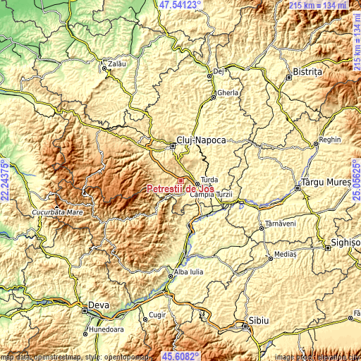
| \ | Map #1 | Topo.Map |
| Scale [m] | 415..791 m | × |
| Scale [ft] | 1362..2595 ft | × |
| Average | 551.7 m = 1810 ft | × |
| Width | 6.72 km = 4.2 mi | 214.9 km = 133.5 mi |
| Height | 6.72 km = 4.2 mi | 214.9 km = 133.5 mi |
| ↑Max Latitude | 46.613525° | 47.54123° |
| Latitude at center | 46.58333° | 46.58333° |
| ↓Min Latitude | 46.553118° | 45.6082° |
| ← Min Longitude | 23.606055° | 22.24375° |
| Longitude center | 23.65° | 23.65° |
| →Max Longitude | 23.693945° | 25.05625° |
Nearby cities:
Cities around Petreştii de Jos sort by population:
• Turda elevation 324 m
10.4 km,  100°
100°
• Mihai Viteazu 330 m
9.5 km,  126°
126°
• Iara 454 m
10.8 km,  250°
250°
• Feleacu 690 m
15 km,  350°
350°
• Moldoveneşti 505 m
9.3 km,  180°
180°
• Tureni 521 m
6.5 km,  38°
38°
• Băişoara 545 m
14 km,  270°
270°
• Sănduleşti 459 m
5.1 km,  90°
90°
• Ciurila 652 m
10.6 km,  314°
314°
• Aiton 628 m
12.8 km,  29°
29°
• Gheorghieni 556 m
14.8 km,  11°
11°
• Copăceni 384 m
7 km,  77°
77°
Multilingual:
 En español:
Petreştii de Jos elevación 471 m.
 En France:
Petreştii de Jos élévation 471 m.
 Auf Deutsch:
Petreştii de Jos höhe über dem Meeresspiegel ist 471 m.

Sources and notes:
- [note 1] Map square and city borders are not equal. Map elevation data is calculated only from area inside that square.
- [src 1] Elevation data from geonames database provided with same terms of usage.
- [src 2] The elevation map of Petreştii de Jos is generated using elevation data from NASA's 3 arcsec (90m) resolution SRTM data.
- [src 3] Base (background) map © OpenStreetMap contributors tiles are generated by Geofabrik and OpenTopoMap.
Copyright & License:
This Petreştii de Jos Elevation Map is licensed under CC BY-SA. You may reuse any part from this page, if you give a proper credit by linking to this URL:
 More info on terms of use page.