Pârcovaci elevation
Pârcovaci (Iaşi, Oraş Hârlãu), Romania elevation is 155 meters and Pârcovaci elevation in feet is 509 ft above sea level [src 1]. Pârcovaci is a populated place (feature code) with elevation that is 97 meters (318 ft) smaller than average city elevation in Romania.
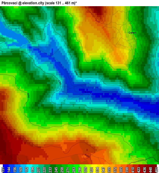
Below is the Elevation map of Pârcovaci, which displays elevation range with different colors. Scale of the first map is from 131 to 461 m (430 to 1512 ft) with average elevation of 273.9 meters (=899 ft) [note 1]
These maps also provides idea of topography and contour of this city, they are displayed at different zoom levels. More info about maps, scale and edge coordinates you can find below images.
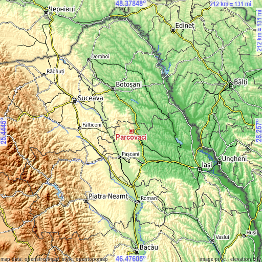
| \ | Map #1 | Topo.Map |
| Scale [m] | 131..461 m | × |
| Scale [ft] | 430..1512 ft | × |
| Average | 273.9 m = 899 ft | × |
| Width | 6.61 km = 4.1 mi | 211.5 km = 131.4 mi |
| Height | 6.61 km = 4.1 mi | 211.5 km = 131.4 mi |
| ↑Max Latitude | 47.465577° | 48.37848° |
| Latitude at center | 47.43586° | 47.43586° |
| ↓Min Latitude | 47.406126° | 46.47605° |
| ← Min Longitude | 26.806805° | 25.4445° |
| Longitude center | 26.85075° | 26.85075° |
| →Max Longitude | 26.894695° | 28.257° |
Nearby cities:
Cities around Pârcovaci sort by population:
• Hârlău elevation 153 m
3.7 km,  94°
94°
• Deleni 258 m
4.2 km,  35°
35°
• Scobinţi 125 m
8.5 km,  133°
133°
• Maxut 202 m
3.1 km,  80°
80°
• Buhalnița 184 m
8 km,  142°
142°
• Sticlăria 393 m
4 km,  193°
193°
• Bădeni 125 m
8.1 km,  114°
114°
• Poiana 323 m
6.4 km,  8°
8°
• Fetești 206 m
5.3 km,  124°
124°
• Slobozia 189 m
5.4 km,  32°
32°
• Poiana Mărului 239 m
7 km,  153°
153°
• Zagavia 188 m
4 km, 117°
Multilingual:
 En español:
Pârcovaci elevación 155 m.
 En France:
Pârcovaci élévation 155 m.
 Auf Deutsch:
Pârcovaci höhe über dem Meeresspiegel ist 155 m.

Sources and notes:
- [note 1] Map square and city borders are not equal. Map elevation data is calculated only from area inside that square.
- [src 1] Elevation data from geonames database provided with same terms of usage.
- [src 2] The elevation map of Pârcovaci is generated using elevation data from NASA's 3 arcsec (90m) resolution SRTM data.
- [src 3] Base (background) map © OpenStreetMap contributors tiles are generated by Geofabrik and OpenTopoMap.
Copyright & License:
This Pârcovaci Elevation Map is licensed under CC BY-SA. You may reuse any part from this page, if you give a proper credit by linking to this URL:
 More info on terms of use page.