Răstoliţa elevation
Răstoliţa (Mureş, Comuna Răstoliţa), Romania elevation is 522 meters and Răstoliţa elevation in feet is 1713 ft above sea level [src 1]. Răstoliţa is a seat of a second-order administrative division (feature code) with elevation that is 270 meters (886 ft) bigger than average city elevation in Romania.
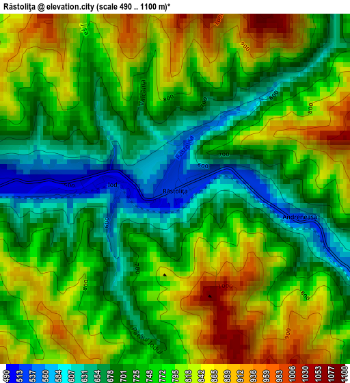
Below is the Elevation map of Răstoliţa, which displays elevation range with different colors. Scale of the first map is from 490 to 1100 m (1608 to 3609 ft) with average elevation of 758.2 meters (=2488 ft) [note 1]
These maps also provides idea of topography and contour of this city, they are displayed at different zoom levels. More info about maps, scale and edge coordinates you can find below images.
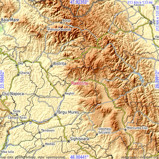
| \ | Map #1 | Topo.Map |
| Scale [m] | 490..1100 m | × |
| Scale [ft] | 1608..3609 ft | × |
| Average | 758.2 m = 2488 ft | × |
| Width | 6.67 km = 4.1 mi | 213.4 km = 132.6 mi |
| Height | 6.67 km = 4.1 mi | 213.4 km = 132.6 mi |
| ↑Max Latitude | 47.002558° | 47.92353° |
| Latitude at center | 46.97258° | 46.97258° |
| ↓Min Latitude | 46.942586° | 46.00441° |
| ← Min Longitude | 24.948925° | 23.58662° |
| Longitude center | 24.99287° | 24.99287° |
| →Max Longitude | 25.036815° | 26.39912° |
Nearby cities:
Cities around Răstoliţa sort by population:
• Ibăneşti elevation 491 m
23.3 km,  191°
191°
• Deda 561 m
8.3 km,  238°
238°
• Aluniş 412 m
17.2 km, 239°
• Ruşii Munţi 456 m
12.5 km, 240°
• Lunca Bradului 579 m
9.2 km,  101°
101°
• Vătava 635 m
17.2 km,  267°
267°
• Toaca 557 m
19.3 km, 186°
• Monor 561 m
22.2 km, 268°
• Vălenii de Mureș 412 m
17.3 km, 239°
• Bistra Mureșului 484 m
6.7 km,  258°
258°
• Stânceni 882 m
18.3 km,  86°
86°
• Brâncoveneşti 395 m
21.9 km,  233°
233°
Multilingual:
 En español:
Răstoliţa elevación 522 m.
 En France:
Răstoliţa élévation 522 m.
 Auf Deutsch:
Răstoliţa höhe über dem Meeresspiegel ist 522 m.

Sources and notes:
- [note 1] Map square and city borders are not equal. Map elevation data is calculated only from area inside that square.
- [src 1] Elevation data from geonames database provided with same terms of usage.
- [src 2] The elevation map of Răstoliţa is generated using elevation data from NASA's 3 arcsec (90m) resolution SRTM data.
- [src 3] Base (background) map © OpenStreetMap contributors tiles are generated by Geofabrik and OpenTopoMap.
Copyright & License:
This Răstoliţa Elevation Map is licensed under CC BY-SA. You may reuse any part from this page, if you give a proper credit by linking to this URL:
 More info on terms of use page.