Ibăneşti elevation
Ibăneşti (Mureş, Comuna Ibăneşti Pădure), Romania elevation is 491 meters and Ibăneşti elevation in feet is 1611 ft above sea level [src 1]. Ibăneşti is a populated place (feature code) with elevation that is 239 meters (784 ft) bigger than average city elevation in Romania.
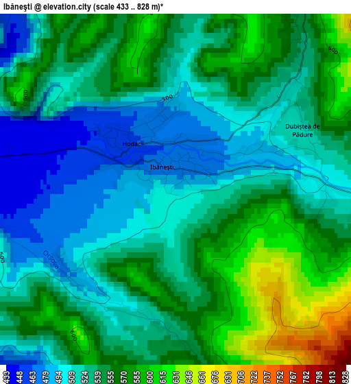
Below is the Elevation map of Ibăneşti, which displays elevation range with different colors. Scale of the first map is from 433 to 828 m (1421 to 2717 ft) with average elevation of 540.4 meters (=1773 ft) [note 1]
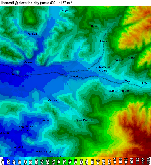
These maps also provides idea of topography and contour of this city, they are displayed at different zoom levels. More info about maps, scale and edge coordinates you can find below images.
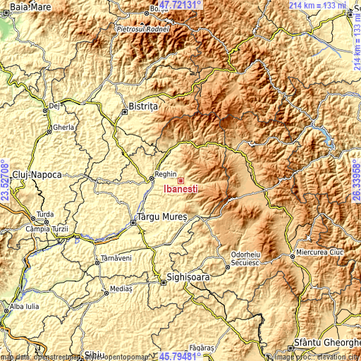
| \ | Map #1 | Map #2 | Topo.Map |
| Scale [m] | 433..828 m | 400..1187 m | × |
| Scale [ft] | 1421..2717 ft | 1312..3894 ft | × |
| Average | 540.4 m = 1773 ft | 619.2 m = 2031 ft | × |
| Width | 6.69 km = 4.2 mi | 13.39 km = 8.3 mi | 214.2 km = 133.1 mi |
| Height | 6.69 km = 4.2 mi | 13.39 km = 8.3 mi | 214.2 km = 133.1 mi |
| ↑Max Latitude | 46.796763° | 46.826839° | 47.72131° |
| Latitude at center | 46.76667° | 46.76667° | 46.76667° |
| ↓Min Latitude | 46.73656° | 46.706434° | 45.79481° |
| ← Min Longitude | 24.889385° | 24.845439° | 23.52708° |
| Longitude center | 24.93333° | 24.93333° | 24.93333° |
| →Max Longitude | 24.977275° | 25.021221° | 26.33958° |
Nearby cities:
Cities around Ibăneşti sort by population:
• Gurghiu elevation 417 m
6.3 km,  270°
270°
• Hodac 477 m
1.3 km, 270°
• Eremitu 541 m
11.1 km,  180°
180°
• Solovăstru 404 m
12.7 km, 270°
• Suseni 377 m
16.2 km,  288°
288°
• Beica de Jos 381 m
10.8 km,  249°
249°
• Ideciu de Jos 376 m
14.4 km,  284°
284°
• Toaca 557 m
4.4 km,  32°
32°
• Chiheru de Jos 447 m
10 km,  202°
202°
• Iernuțeni 361 m
16.3 km, 268°
• Jabenița 394 m
10.6 km, 280°
• Ibănești-Pădure 583 m
4.2 km,  101°
101°
Multilingual:
 En español:
Ibăneşti elevación 491 m.
 En France:
Ibăneşti élévation 491 m.
 Auf Deutsch:
Ibăneşti höhe über dem Meeresspiegel ist 491 m.

Sources and notes:
- [note 1] Map square and city borders are not equal. Map elevation data is calculated only from area inside that square.
- [src 1] Elevation data from geonames database provided with same terms of usage.
- [src 2] The elevation map of Ibăneşti is generated using elevation data from NASA's 3 arcsec (90m) resolution SRTM data.
- [src 3] Base (background) map © OpenStreetMap contributors tiles are generated by Geofabrik and OpenTopoMap.
Copyright & License:
This Ibăneşti Elevation Map is licensed under CC BY-SA. You may reuse any part from this page, if you give a proper credit by linking to this URL:
 More info on terms of use page.