Răzvad elevation
Răzvad (Dâmboviţa, Comuna Rãzvad), Romania elevation is 260 meters and Răzvad elevation in feet is 853 ft above sea level [src 1]. Răzvad is a populated place (feature code) with elevation that is 8 meters (26 ft) bigger than average city elevation in Romania.
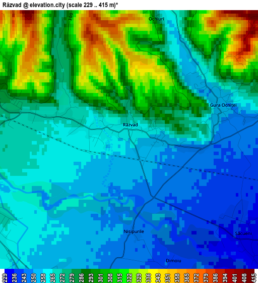
Below is the Elevation map of Răzvad, which displays elevation range with different colors. Scale of the first map is from 229 to 415 m (751 to 1362 ft) with average elevation of 276.6 meters (=907 ft) [note 1]
These maps also provides idea of topography and contour of this city, they are displayed at different zoom levels. More info about maps, scale and edge coordinates you can find below images.
| \ | Map #1 | Map #2 | Topo.Map |
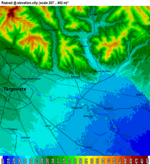
| Scale [m] | 229..415 m | 207..492 m | × |
| Scale [ft] | 751..1362 ft | 679..1614 ft | × |
| Average | 276.6 m = 907 ft | 282.7 m = 927 ft | × |
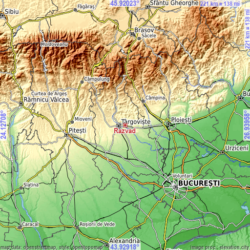
| Width | 6.92 km = 4.3 mi | 13.84 km = 8.6 mi | 221.4 km = 137.6 mi |
| Height | 6.92 km = 4.3 mi | 13.84 km = 8.6 mi | 221.4 km = 137.6 mi |
| ↑Max Latitude | 44.964432° | 44.995517° | 45.92023° |
| Latitude at center | 44.93333° | 44.93333° | 44.93333° |
| ↓Min Latitude | 44.902211° | 44.871076° | 43.92918° |
| ← Min Longitude | 25.489385° | 25.445439° | 24.12708° |
| Longitude center | 25.53333° | 25.53333° | 25.53333° |
| →Max Longitude | 25.577275° | 25.621221° | 26.93958° |
Nearby cities:
Cities around Răzvad sort by population:
• Târgovişte elevation 283 m
6.1 km,  261°
261°
• Aninoasa 307 m
8.7 km,  295°
295°
• Comişani 226 m
6.8 km,  144°
144°
• Ocniţa 270 m
5.7 km,  13°
13°
• Ulmi 254 m
4.5 km,  215°
215°
• Gura Ocniței 258 m
2.9 km,  71°
71°
• Valea Voievozilor 272 m
3.8 km,  277°
277°
• Viforâta 302 m
6.6 km, 296°
• Adânca 235 m
6.2 km,  101°
101°
• Lazuri 236 m
6.2 km,  168°
168°
• Săcueni 237 m
4 km,  129°
129°
• Gorgota 300 m
5.2 km,  337°
337°
Multilingual:
 En español:
Răzvad elevación 260 m.
 En France:
Răzvad élévation 260 m.


Sources and notes:
- [note 1] Map square and city borders are not equal. Map elevation data is calculated only from area inside that square.
- [src 1] Elevation data from geonames database provided with same terms of usage.
- [src 2] The elevation map of Răzvad is generated using elevation data from NASA's 3 arcsec (90m) resolution SRTM data.
- [src 3] Base (background) map © OpenStreetMap contributors tiles are generated by Geofabrik and OpenTopoMap.
Copyright & License:
This Răzvad Elevation Map is licensed under CC BY-SA. You may reuse any part from this page, if you give a proper credit by linking to this URL:
 More info on terms of use page.