Recea elevation
Recea (Maramureş, Comuna Recea), Romania elevation is 190 meters and Recea elevation in feet is 623 ft above sea level [src 1]. Recea is a seat of a second-order administrative division (feature code) with elevation that is 62 meters (203 ft) smaller than average city elevation in Romania.
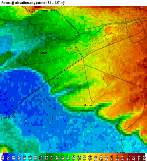
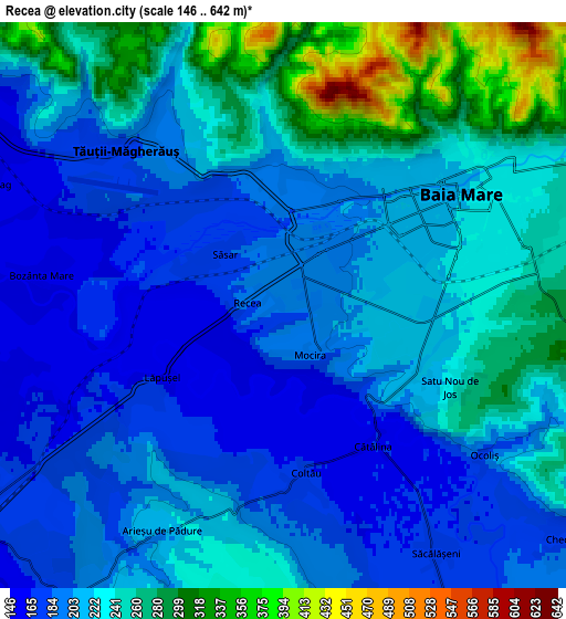
Below is the Elevation map of Recea, which displays elevation range with different colors. Scale of the first map is from 152 to 227 m (499 to 745 ft) with average elevation of 182.4 meters (=598 ft) [note 1]
These maps also provides idea of topography and contour of this city, they are displayed at different zoom levels. More info about maps, scale and edge coordinates you can find below images.
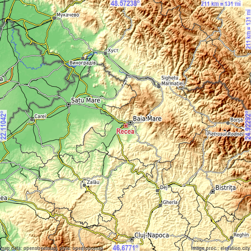
| \ | Map #1 | Map #2 | Topo.Map |
| Scale [m] | 152..227 m | 146..642 m | × |
| Scale [ft] | 499..745 ft | 479..2106 ft | × |
| Average | 182.4 m = 598 ft | 221.5 m = 727 ft | × |
| Width | 6.59 km = 4.1 mi | 13.17 km = 8.2 mi | 210.7 km = 130.9 mi |
| Height | 6.59 km = 4.1 mi | 13.17 km = 8.2 mi | 210.7 km = 130.9 mi |
| ↑Max Latitude | 47.662935° | 47.692524° | 48.57238° |
| Latitude at center | 47.63333° | 47.63333° | 47.63333° |
| ↓Min Latitude | 47.603708° | 47.574069° | 46.6771° |
| ← Min Longitude | 23.472725° | 23.428779° | 22.11042° |
| Longitude center | 23.51667° | 23.51667° | 23.51667° |
| →Max Longitude | 23.560615° | 23.604561° | 24.92292° |
Nearby cities:
Cities around Recea sort by population:
• Baia Mare elevation 220 m
4.7 km,  55°
55°
• Satulung 164 m
9.7 km,  220°
220°
• Dumbrăviţa 197 m
10.7 km,  110°
110°
• Tăuții-Măgherăuș 170 m
3.1 km,  306°
306°
• Groşi 235 m
7.7 km,  103°
103°
• Băița 248 m
8.3 km,  347°
347°
• Cicârlău 162 m
10.6 km, 307°
• Săsar 183 m
1.8 km, 311°
• Coltău 169 m
3.9 km,  171°
171°
• Lăpușel 164 m
3.3 km,  239°
239°
• Nistru 376 m
10.8 km,  334°
334°
• Săcălășeni 170 m
6.8 km,  148°
148°
Multilingual:
 En español:
Recea elevación 190 m.
 En France:
Recea élévation 190 m.


Sources and notes:
- [note 1] Map square and city borders are not equal. Map elevation data is calculated only from area inside that square.
- [src 1] Elevation data from geonames database provided with same terms of usage.
- [src 2] The elevation map of Recea is generated using elevation data from NASA's 3 arcsec (90m) resolution SRTM data.
- [src 3] Base (background) map © OpenStreetMap contributors tiles are generated by Geofabrik and OpenTopoMap.
Copyright & License:
This Recea Elevation Map is licensed under CC BY-SA. You may reuse any part from this page, if you give a proper credit by linking to this URL:
 More info on terms of use page.