Recea Cristur elevation
Recea Cristur (Cluj, Comuna Recea Cristur), Romania elevation is 401 meters and Recea Cristur elevation in feet is 1316 ft above sea level [src 1]. Recea Cristur is a seat of a second-order administrative division (feature code) with elevation that is 149 meters (489 ft) bigger than average city elevation in Romania.
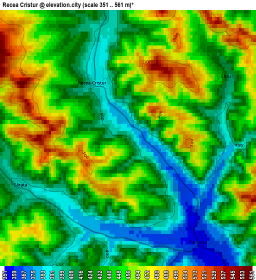
Below is the Elevation map of Recea Cristur, which displays elevation range with different colors. Scale of the first map is from 351 to 561 m (1152 to 1841 ft) with average elevation of 436.7 meters (=1433 ft) [note 1]
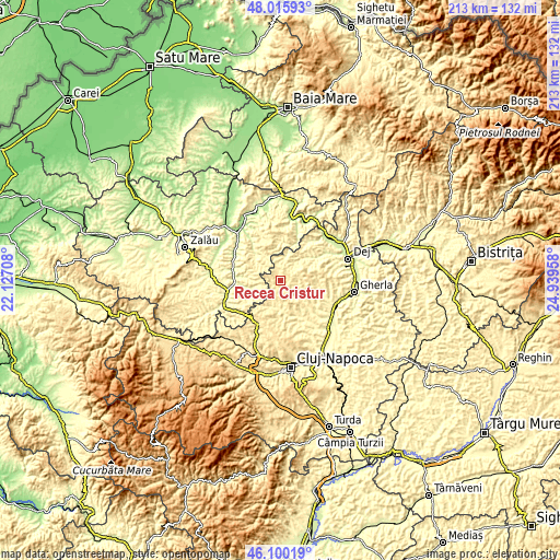
These maps also provides idea of topography and contour of this city, they are displayed at different zoom levels. More info about maps, scale and edge coordinates you can find below images.
| \ | Map #1 | Topo.Map |
| Scale [m] | 351..561 m | × |
| Scale [ft] | 1152..1841 ft | × |
| Average | 436.7 m = 1433 ft | × |
| Width | 6.66 km = 4.1 mi | 213 km = 132.4 mi |
| Height | 6.66 km = 4.1 mi | 213 km = 132.4 mi |
| ↑Max Latitude | 47.096595° | 48.01593° |
| Latitude at center | 47.06667° | 47.06667° |
| ↓Min Latitude | 47.036728° | 46.10019° |
| ← Min Longitude | 23.489385° | 22.12708° |
| Longitude center | 23.53333° | 23.53333° |
| →Max Longitude | 23.577275° | 24.93958° |
Nearby cities:
Cities around Recea Cristur sort by population:
• Gârbou elevation 354 m
12 km,  320°
320°
• Panticeu 350 m
4.5 km,  145°
145°
• Borşa 336 m
17.9 km, 145°
• Aşchileu Dorna 436 m
10 km,  202°
202°
• Dăbâca 369 m
13.7 km,  132°
132°
• Corneşti 370 m
12 km,  108°
108°
• Vultureni 423 m
11.4 km,  167°
167°
• Dragu 336 m
11.5 km,  241°
241°
• Cristolţ 352 m
16.6 km,  332°
332°
• Aluniş 318 m
16.8 km,  102°
102°
• Zalha 433 m
13 km,  0°
0°
• Bobâlna 311 m
12 km,  44°
44°
Multilingual:
 En español:
Recea Cristur elevación 401 m.
 En France:
Recea Cristur élévation 401 m.
 Auf Deutsch:
Recea Cristur höhe über dem Meeresspiegel ist 401 m.

Sources and notes:
- [note 1] Map square and city borders are not equal. Map elevation data is calculated only from area inside that square.
- [src 1] Elevation data from geonames database provided with same terms of usage.
- [src 2] The elevation map of Recea Cristur is generated using elevation data from NASA's 3 arcsec (90m) resolution SRTM data.
- [src 3] Base (background) map © OpenStreetMap contributors tiles are generated by Geofabrik and OpenTopoMap.
Copyright & License:
This Recea Cristur Elevation Map is licensed under CC BY-SA. You may reuse any part from this page, if you give a proper credit by linking to this URL:
 More info on terms of use page.