Rodna elevation
Rodna (Bistriţa-Năsăud, Comuna Rodna), Romania elevation is 525 meters and Rodna elevation in feet is 1722 ft above sea level [src 1]. Rodna is a seat of a second-order administrative division (feature code) with elevation that is 273 meters (896 ft) bigger than average city elevation in Romania.
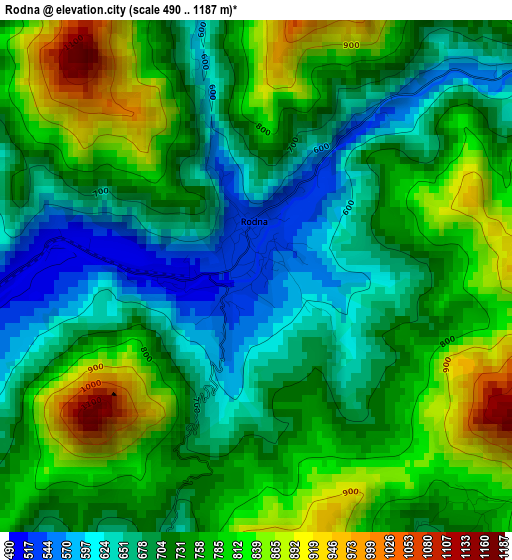
Below is the Elevation map of Rodna, which displays elevation range with different colors. Scale of the first map is from 490 to 1187 m (1608 to 3894 ft) with average elevation of 737.8 meters (=2421 ft) [note 1]
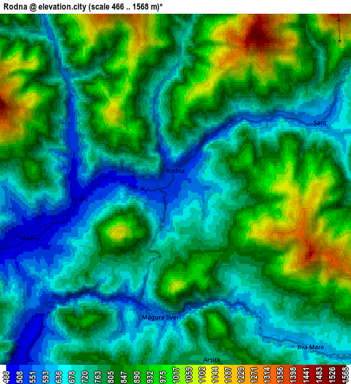
These maps also provides idea of topography and contour of this city, they are displayed at different zoom levels. More info about maps, scale and edge coordinates you can find below images.
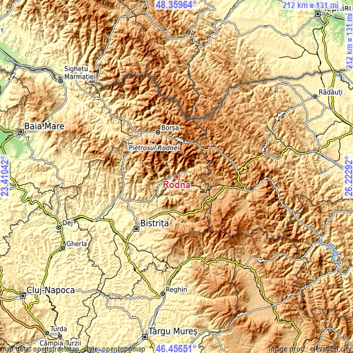
| \ | Map #1 | Map #2 | Topo.Map |
| Scale [m] | 490..1187 m | 466..1568 m | × |
| Scale [ft] | 1608..3894 ft | 1529..5144 ft | × |
| Average | 737.8 m = 2421 ft | 800.2 m = 2625 ft | × |
| Width | 6.61 km = 4.1 mi | 13.23 km = 8.2 mi | 211.6 km = 131.5 mi |
| Height | 6.61 km = 4.1 mi | 13.23 km = 8.2 mi | 211.6 km = 131.5 mi |
| ↑Max Latitude | 47.446398° | 47.476109° | 48.35964° |
| Latitude at center | 47.41667° | 47.41667° | 47.41667° |
| ↓Min Latitude | 47.386925° | 47.357164° | 46.45651° |
| ← Min Longitude | 24.772725° | 24.728779° | 23.41042° |
| Longitude center | 24.81667° | 24.81667° | 24.81667° |
| →Max Longitude | 24.860615° | 24.904561° | 26.22292° |
Nearby cities:
Cities around Rodna sort by population:
• Cormaia elevation 456 m
11.5 km,  241°
241°
• Sângeorz-Băi 434 m
12.1 km, 243°
• Măieru 496 m
5.3 km,  249°
249°
• Măgura Ilvei 623 m
3.9 km,  198°
198°
• Lunca Ilvei 751 m
13.7 km,  113°
113°
• Leşu 582 m
12.2 km, 204°
• Șanț 644 m
7.3 km,  59°
59°
• Ilva Mare 702 m
8.4 km,  131°
131°
• Poiana Ilvei 497 m
8.7 km,  220°
220°
• Anieș 490 m
3.6 km,  264°
264°
• Lunca Leșului 544 m
12.3 km,  194°
194°
• Valea Borcutului 462 m
13.2 km, 249°
Multilingual:
 En español:
Rodna elevación 525 m.
 En France:
Rodna élévation 525 m.


Sources and notes:
- [note 1] Map square and city borders are not equal. Map elevation data is calculated only from area inside that square.
- [src 1] Elevation data from geonames database provided with same terms of usage.
- [src 2] The elevation map of Rodna is generated using elevation data from NASA's 3 arcsec (90m) resolution SRTM data.
- [src 3] Base (background) map © OpenStreetMap contributors tiles are generated by Geofabrik and OpenTopoMap.
Copyright & License:
This Rodna Elevation Map is licensed under CC BY-SA. You may reuse any part from this page, if you give a proper credit by linking to this URL:
 More info on terms of use page.