Lunca Leșului elevation
Lunca Leșului (Bistriţa-Năsăud, Comuna Leşu), Romania elevation is 544 meters and Lunca Leșului elevation in feet is 1785 ft above sea level [src 1]. Lunca Leșului is a populated place (feature code) with elevation that is 292 meters (958 ft) bigger than average city elevation in Romania.
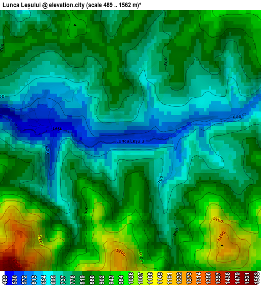
Below is the Elevation map of Lunca Leșului, which displays elevation range with different colors. Scale of the first map is from 489 to 1562 m (1604 to 5125 ft) with average elevation of 819 meters (=2687 ft) [note 1]
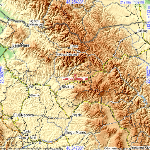
These maps also provides idea of topography and contour of this city, they are displayed at different zoom levels. More info about maps, scale and edge coordinates you can find below images.
| \ | Map #1 | Topo.Map |
| Scale [m] | 489..1562 m | × |
| Scale [ft] | 1604..5125 ft | × |
| Average | 819 m = 2687 ft | × |
| Width | 6.63 km = 4.1 mi | 212 km = 131.7 mi |
| Height | 6.63 km = 4.1 mi | 212 km = 131.7 mi |
| ↑Max Latitude | 47.339218° | 48.25433° |
| Latitude at center | 47.30943° | 47.30943° |
| ↓Min Latitude | 47.279625° | 46.34733° |
| ← Min Longitude | 24.732075° | 23.36977° |
| Longitude center | 24.77602° | 24.77602° |
| →Max Longitude | 24.819965° | 26.18227° |
Nearby cities:
Cities around Lunca Leșului sort by population:
• Cormaia elevation 456 m
9.4 km,  312°
312°
• Sângeorz-Băi 434 m
10.2 km, 309°
• Măieru 496 m
10.3 km,  348°
348°
• Prundu Bârgăului 518 m
10.3 km,  194°
194°
• Tiha Bârgăului 611 m
8.5 km,  184°
184°
• Măgura Ilvei 623 m
8.4 km,  12°
12°
• Ilva Mică 637 m
8.3 km,  275°
275°
• Leşu 582 m
2.1 km,  292°
292°
• Tureac 571 m
9.2 km,  165°
165°
• Poiana Ilvei 497 m
6 km,  333°
333°
• Susenii Bârgăului 484 m
10.9 km,  208°
208°
• Bistriţa Bârgăului 569 m
10.3 km, 183°
Multilingual:
 En español:
Lunca Leșului elevación 544 m.
 En France:
Lunca Leșului élévation 544 m.
 Auf Deutsch:
Lunca Leșului höhe über dem Meeresspiegel ist 544 m.

Sources and notes:
- [note 1] Map square and city borders are not equal. Map elevation data is calculated only from area inside that square.
- [src 1] Elevation data from geonames database provided with same terms of usage.
- [src 2] The elevation map of Lunca Leșului is generated using elevation data from NASA's 3 arcsec (90m) resolution SRTM data.
- [src 3] Base (background) map © OpenStreetMap contributors tiles are generated by Geofabrik and OpenTopoMap.
Copyright & License:
This Lunca Leșului Elevation Map is licensed under CC BY-SA. You may reuse any part from this page, if you give a proper credit by linking to this URL:
 More info on terms of use page.