Săcele elevation
Săcele (Braşov, Municipiul Sãcele), Romania elevation is 652 meters and Săcele elevation in feet is 2139 ft above sea level [src 1]. Săcele is a seat of a second-order administrative division (feature code) with elevation that is 400 meters (1312 ft) bigger than average city elevation in Romania.
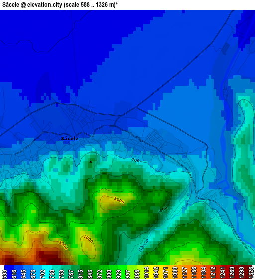
Below is the Elevation map of Săcele, which displays elevation range with different colors. Scale of the first map is from 588 to 1326 m (1929 to 4350 ft) with average elevation of 714.5 meters (=2344 ft) [note 1]
These maps also provides idea of topography and contour of this city, they are displayed at different zoom levels. More info about maps, scale and edge coordinates you can find below images.
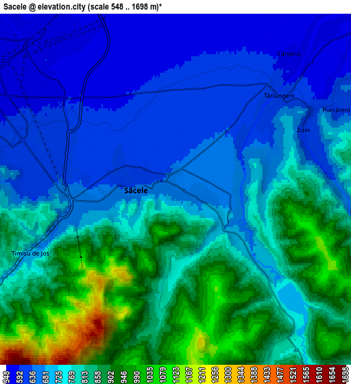
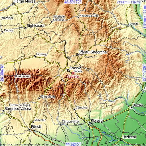
| \ | Map #1 | Map #2 | Topo.Map |
| Scale [m] | 588..1326 m | 548..1698 m | × |
| Scale [ft] | 1929..4350 ft | 1798..5571 ft | × |
| Average | 714.5 m = 2344 ft | 762.2 m = 2501 ft | × |
| Width | 6.84 km = 4.3 mi | 13.67 km = 8.5 mi | 218.7 km = 135.9 mi |
| Height | 6.84 km = 4.3 mi | 13.67 km = 8.5 mi | 218.7 km = 135.9 mi |
| ↑Max Latitude | 45.647469° | 45.678182° | 46.59172° |
| Latitude at center | 45.61674° | 45.61674° | 45.61674° |
| ↓Min Latitude | 45.585994° | 45.555231° | 44.6245° |
| ← Min Longitude | 25.667065° | 25.623119° | 24.30476° |
| Longitude center | 25.71101° | 25.71101° | 25.71101° |
| →Max Longitude | 25.754955° | 25.798901° | 27.11726° |
Nearby cities:
Cities around Săcele sort by population:
• Braşov elevation 573 m
8.9 km,  293°
293°
• Prejmer 523 m
11.9 km,  21°
21°
• Tărlungeni 632 m
3.5 km,  58°
58°
• Predeal 1110 m
17.2 km,  220°
220°
• Ghimbav 557 m
17.3 km, 288°
• Hărman 522 m
11.3 km,  349°
349°
• Tunelu-Teliu 543 m
14.2 km,  49°
49°
• Teliu 543 m
14.5 km, 51°
• Budila 564 m
8.9 km, 51°
• Sânpetru 528 m
11.9 km,  331°
331°
• Zizin 611 m
5.7 km,  66°
66°
• Purcăreni 603 m
7 km, 63°
Multilingual:
 En español:
Săcele elevación 652 m.
 En France:
Săcele élévation 652 m.


Sources and notes:
- [note 1] Map square and city borders are not equal. Map elevation data is calculated only from area inside that square.
- [src 1] Elevation data from geonames database provided with same terms of usage.
- [src 2] The elevation map of Săcele is generated using elevation data from NASA's 3 arcsec (90m) resolution SRTM data.
- [src 3] Base (background) map © OpenStreetMap contributors tiles are generated by Geofabrik and OpenTopoMap.
Copyright & License:
This Săcele Elevation Map is licensed under CC BY-SA. You may reuse any part from this page, if you give a proper credit by linking to this URL:
 More info on terms of use page.