Tunelu-Teliu elevation
Tunelu-Teliu (Braşov, Comuna Teliu), Romania elevation is 543 meters and Tunelu-Teliu elevation in feet is 1781 ft above sea level [src 1]. Tunelu-Teliu is a populated place (feature code) with elevation that is 291 meters (955 ft) bigger than average city elevation in Romania.
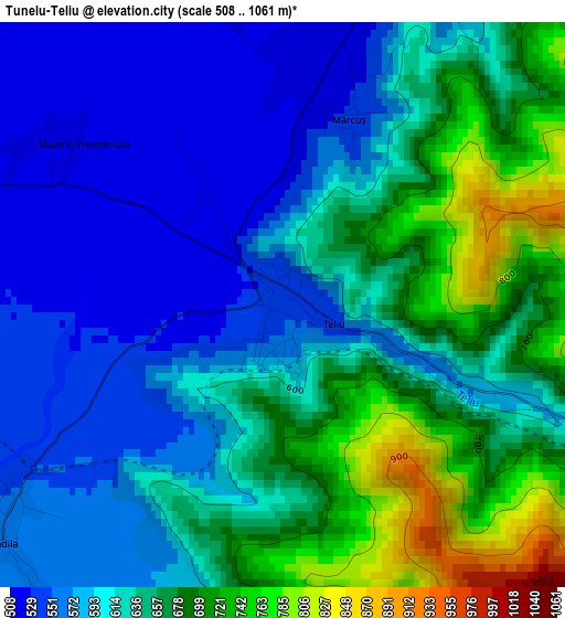
Below is the Elevation map of Tunelu-Teliu, which displays elevation range with different colors. Scale of the first map is from 508 to 1061 m (1667 to 3481 ft) with average elevation of 627.7 meters (=2059 ft) [note 1]
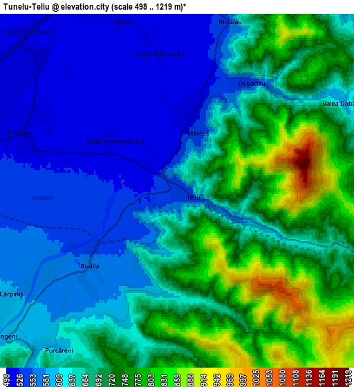
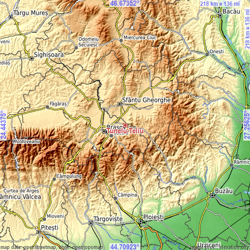
These maps also provides idea of topography and contour of this city, they are displayed at different zoom levels. More info about maps, scale and edge coordinates you can find below images.
| \ | Map #1 | Map #2 | Topo.Map |
| Scale [m] | 508..1061 m | 498..1219 m | × |
| Scale [ft] | 1667..3481 ft | 1634..3999 ft | × |
| Average | 627.7 m = 2059 ft | 658.4 m = 2160 ft | × |
| Width | 6.83 km = 4.2 mi | 13.65 km = 8.5 mi | 218.4 km = 135.7 mi |
| Height | 6.83 km = 4.2 mi | 13.65 km = 8.5 mi | 218.4 km = 135.7 mi |
| ↑Max Latitude | 45.730684° | 45.76135° | 46.67352° |
| Latitude at center | 45.7° | 45.7° | 45.7° |
| ↓Min Latitude | 45.669299° | 45.638582° | 44.70923° |
| ← Min Longitude | 25.806055° | 25.762109° | 24.44375° |
| Longitude center | 25.85° | 25.85° | 25.85° |
| →Max Longitude | 25.893945° | 25.937891° | 27.25625° |
Nearby cities:
Cities around Tunelu-Teliu sort by population:
• Prejmer elevation 523 m
6.7 km,  285°
285°
• Tărlungeni 632 m
10.7 km,  226°
226°
• Ozun 513 m
11.1 km,  0°
0°
• Teliu 543 m
0.5 km,  109°
109°
• Budila 564 m
5.4 km, 226°
• Dobârlău 610 m
4.5 km,  34°
34°
• Zizin 611 m
8.9 km,  218°
218°
• Ilieni 523 m
12.9 km,  329°
329°
• Chichiş 506 m
10 km,  337°
337°
• Purcăreni 603 m
7.7 km, 216°
• Floroaia 719 m
12.9 km,  92°
92°
• Acriș 732 m
13.1 km,  122°
122°
Multilingual:
 En español:
Tunelu-Teliu elevación 543 m.
 En France:
Tunelu-Teliu élévation 543 m.
 Auf Deutsch:
Tunelu-Teliu höhe über dem Meeresspiegel ist 543 m.

Sources and notes:
- [note 1] Map square and city borders are not equal. Map elevation data is calculated only from area inside that square.
- [src 1] Elevation data from geonames database provided with same terms of usage.
- [src 2] The elevation map of Tunelu-Teliu is generated using elevation data from NASA's 3 arcsec (90m) resolution SRTM data.
- [src 3] Base (background) map © OpenStreetMap contributors tiles are generated by Geofabrik and OpenTopoMap.
Copyright & License:
This Tunelu-Teliu Elevation Map is licensed under CC BY-SA. You may reuse any part from this page, if you give a proper credit by linking to this URL:
 More info on terms of use page.