Sălătrucel elevation
Sălătrucel (Vâlcea, Comuna Sălătrucel), Romania elevation is 348 meters and Sălătrucel elevation in feet is 1142 ft above sea level [src 1]. Sălătrucel is a seat of a second-order administrative division (feature code) with elevation that is 96 meters (315 ft) bigger than average city elevation in Romania.
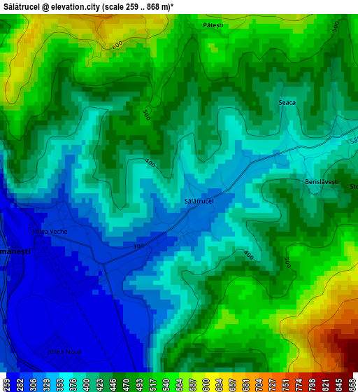
Below is the Elevation map of Sălătrucel, which displays elevation range with different colors. Scale of the first map is from 259 to 868 m (850 to 2848 ft) with average elevation of 432 meters (=1417 ft) [note 1]
These maps also provides idea of topography and contour of this city, they are displayed at different zoom levels. More info about maps, scale and edge coordinates you can find below images.
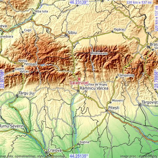
| \ | Map #1 | Topo.Map |
| Scale [m] | 259..868 m | × |
| Scale [ft] | 850..2848 ft | × |
| Average | 432 m = 1417 ft | × |
| Width | 6.88 km = 4.3 mi | 220.2 km = 136.8 mi |
| Height | 6.88 km = 4.3 mi | 220.1 km = 136.8 mi |
| ↑Max Latitude | 45.28093° | 46.23139° |
| Latitude at center | 45.25° | 45.25° |
| ↓Min Latitude | 45.219053° | 44.25135° |
| ← Min Longitude | 24.339385° | 22.97708° |
| Longitude center | 24.38333° | 24.38333° |
| →Max Longitude | 24.427275° | 25.78958° |
Nearby cities:
Cities around Sălătrucel sort by population:
• Călimăneşti elevation 366 m
4.3 km,  244°
244°
• Băile Olăneşti 566 m
13 km, 244°
• Bujoreni 407 m
13.2 km,  191°
191°
• Berislăveşti 398 m
2.6 km,  90°
90°
• Şuici 519 m
11.7 km, 90°
• Muereasca 378 m
8.4 km,  207°
207°
• Sălătrucu 661 m
14 km,  48°
48°
• Jiblea Veche 287 m
2.6 km,  253°
253°
• Livadia 457 m
12.1 km, 245°
• Olănești 403 m
12.3 km,  232°
232°
• Runcu 391 m
10.6 km,  150°
150°
• Dăești 296 m
5.4 km,  177°
177°
Multilingual:
 En español:
Sălătrucel elevación 348 m.
 En France:
Sălătrucel élévation 348 m.
 Auf Deutsch:
Sălătrucel höhe über dem Meeresspiegel ist 348 m.

Sources and notes:
- [note 1] Map square and city borders are not equal. Map elevation data is calculated only from area inside that square.
- [src 1] Elevation data from geonames database provided with same terms of usage.
- [src 2] The elevation map of Sălătrucel is generated using elevation data from NASA's 3 arcsec (90m) resolution SRTM data.
- [src 3] Base (background) map © OpenStreetMap contributors tiles are generated by Geofabrik and OpenTopoMap.
Copyright & License:
This Sălătrucel Elevation Map is licensed under CC BY-SA. You may reuse any part from this page, if you give a proper credit by linking to this URL:
 More info on terms of use page.