Sănduleni elevation
Sănduleni (Bacău, Comuna Sănduleni), Romania elevation is 292 meters and Sănduleni elevation in feet is 958 ft above sea level [src 1]. Sănduleni is a seat of a second-order administrative division (feature code) with elevation that is 40 meters (131 ft) bigger than average city elevation in Romania.
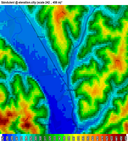
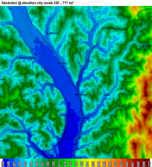
Below is the Elevation map of Sănduleni, which displays elevation range with different colors. Scale of the first map is from 242 to 458 m (794 to 1503 ft) with average elevation of 311.5 meters (=1022 ft) [note 1]
These maps also provides idea of topography and contour of this city, they are displayed at different zoom levels. More info about maps, scale and edge coordinates you can find below images.
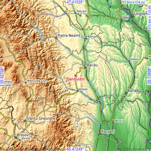
| \ | Map #1 | Map #2 | Topo.Map |
| Scale [m] | 242..458 m | 230..717 m | × |
| Scale [ft] | 794..1503 ft | 755..2352 ft | × |
| Average | 311.5 m = 1022 ft | 355.8 m = 1167 ft | × |
| Width | 6.73 km = 4.2 mi | 13.47 km = 8.4 mi | 215.5 km = 133.9 mi |
| Height | 6.73 km = 4.2 mi | 13.47 km = 8.4 mi | 215.4 km = 133.8 mi |
| ↑Max Latitude | 46.480269° | 46.510522° | 47.41028° |
| Latitude at center | 46.45° | 46.45° | 46.45° |
| ↓Min Latitude | 46.419714° | 46.389411° | 45.47249° |
| ← Min Longitude | 26.689385° | 26.645439° | 25.32708° |
| Longitude center | 26.73333° | 26.73333° | 26.73333° |
| →Max Longitude | 26.777275° | 26.821221° | 28.13958° |
Nearby cities:
Cities around Sănduleni sort by population:
• Bereşti-Tazlău elevation 345 m
5.4 km,  289°
289°
• Berzunţi 344 m
9.5 km,  234°
234°
• Livezi-Vale 246 m
3.7 km,  180°
180°
• Dămoc 261 m
10.4 km,  79°
79°
• Strugari 314 m
9.4 km,  352°
352°
• Drăgugești 285 m
9.6 km,  160°
160°
• Dragomir 347 m
8.8 km,  242°
242°
• Deleni 359 m
11.2 km, 162°
• Turluianu 303 m
6.7 km,  272°
272°
• Orășa 266 m
3.2 km,  165°
165°
• Verșești 280 m
2.4 km, 267°
• Livezi 270 m
4.9 km, 177°
Multilingual:
 En español:
Sănduleni elevación 292 m.
 En France:
Sănduleni élévation 292 m.
 Auf Deutsch:
Sănduleni höhe über dem Meeresspiegel ist 292 m.

Sources and notes:
- [note 1] Map square and city borders are not equal. Map elevation data is calculated only from area inside that square.
- [src 1] Elevation data from geonames database provided with same terms of usage.
- [src 2] The elevation map of Sănduleni is generated using elevation data from NASA's 3 arcsec (90m) resolution SRTM data.
- [src 3] Base (background) map © OpenStreetMap contributors tiles are generated by Geofabrik and OpenTopoMap.
Copyright & License:
This Sănduleni Elevation Map is licensed under CC BY-SA. You may reuse any part from this page, if you give a proper credit by linking to this URL:
 More info on terms of use page.