Scurtu Mare elevation
Scurtu Mare (Teleorman, Comuna Scurtu Mare), Romania elevation is 131 meters and Scurtu Mare elevation in feet is 430 ft above sea level [src 1]. Scurtu Mare is a seat of a second-order administrative division (feature code) with elevation that is 121 meters (397 ft) smaller than average city elevation in Romania.
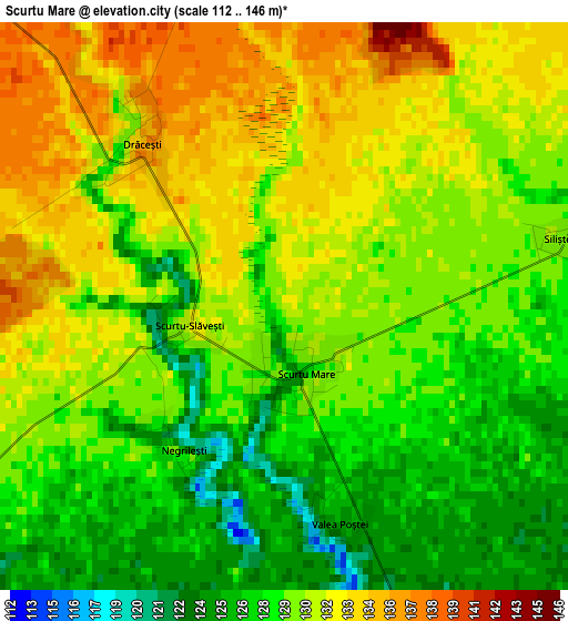
Below is the Elevation map of Scurtu Mare, which displays elevation range with different colors. Scale of the first map is from 112 to 146 m (367 to 479 ft) with average elevation of 129.8 meters (=426 ft) [note 1]
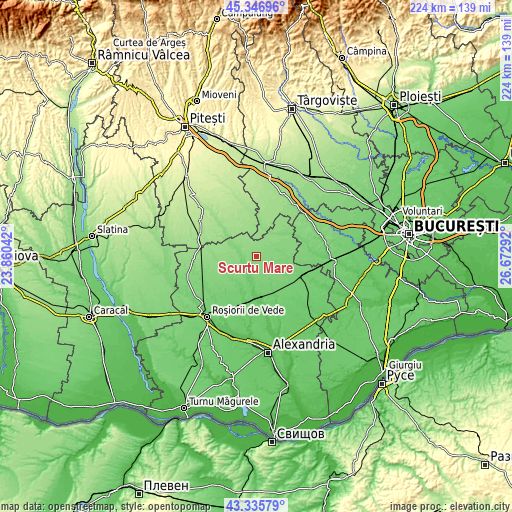
These maps also provides idea of topography and contour of this city, they are displayed at different zoom levels. More info about maps, scale and edge coordinates you can find below images.
| \ | Map #1 | Topo.Map |
| Scale [m] | 112..146 m | × |
| Scale [ft] | 367..479 ft | × |
| Average | 129.8 m = 426 ft | × |
| Width | 6.99 km = 4.3 mi | 223.6 km = 138.9 mi |
| Height | 6.99 km = 4.3 mi | 223.6 km = 138.9 mi |
| ↑Max Latitude | 44.381416° | 45.34696° |
| Latitude at center | 44.35° | 44.35° |
| ↓Min Latitude | 44.318567° | 43.33579° |
| ← Min Longitude | 25.222725° | 23.86042° |
| Longitude center | 25.26667° | 25.26667° |
| →Max Longitude | 25.310615° | 26.67292° |
Nearby cities:
Cities around Scurtu Mare sort by population:
• Siliştea elevation 128 m
7.6 km,  60°
60°
• Poporogi 114 m
6.9 km,  285°
285°
• Trivalea-Moşteni 90 m
9.6 km,  195°
195°
• Poeni 135 m
7.7 km,  43°
43°
• Cosmeşti 112 m
10.8 km,  120°
120°
• Talpa-Trivalea 119 m
7.5 km,  169°
169°
• Tătărăștii de Jos 122 m
7.6 km, 291°
• Udupu 125 m
11 km,  298°
298°
• Ciuperceni 117 m
9.6 km,  112°
112°
• Deparați 94 m
8.5 km,  205°
205°
• Talpa-Ogrăzile 118 m
7.3 km,  163°
163°
• Purani 122 m
12.7 km,  84°
84°
Multilingual:
 En español:
Scurtu Mare elevación 131 m.
 En France:
Scurtu Mare élévation 131 m.
 Auf Deutsch:
Scurtu Mare höhe über dem Meeresspiegel ist 131 m.

Sources and notes:
- [note 1] Map square and city borders are not equal. Map elevation data is calculated only from area inside that square.
- [src 1] Elevation data from geonames database provided with same terms of usage.
- [src 2] The elevation map of Scurtu Mare is generated using elevation data from NASA's 3 arcsec (90m) resolution SRTM data.
- [src 3] Base (background) map © OpenStreetMap contributors tiles are generated by Geofabrik and OpenTopoMap.
Copyright & License:
This Scurtu Mare Elevation Map is licensed under CC BY-SA. You may reuse any part from this page, if you give a proper credit by linking to this URL:
 More info on terms of use page.