Singureni elevation
Singureni (Giurgiu, Comuna Singureni), Romania elevation is 65 meters and Singureni elevation in feet is 213 ft above sea level [src 1]. Singureni is a seat of a second-order administrative division (feature code) with elevation that is 187 meters (614 ft) smaller than average city elevation in Romania.
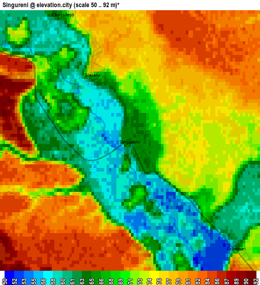
Below is the Elevation map of Singureni, which displays elevation range with different colors. Scale of the first map is from 50 to 92 m (164 to 302 ft) with average elevation of 71.9 meters (=236 ft) [note 1]
These maps also provides idea of topography and contour of this city, they are displayed at different zoom levels. More info about maps, scale and edge coordinates you can find below images.
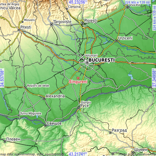
| \ | Map #1 | Topo.Map |
| Scale [m] | 50..92 m | × |
| Scale [ft] | 164..302 ft | × |
| Average | 71.9 m = 236 ft | × |
| Width | 7 km = 4.3 mi | 224.1 km = 139.2 mi |
| Height | 7 km = 4.3 mi | 224.1 km = 139.2 mi |
| ↑Max Latitude | 44.265088° | 45.23256° |
| Latitude at center | 44.23361° | 44.23361° |
| ↓Min Latitude | 44.202115° | 43.21741° |
| ← Min Longitude | 25.899385° | 24.53708° |
| Longitude center | 25.94333° | 25.94333° |
| →Max Longitude | 25.987275° | 27.34958° |
Nearby cities:
Cities around Singureni sort by population:
• 1 Decembrie elevation 64 m
11.1 km,  55°
55°
• Mihăileşti 87 m
10.7 km,  344°
344°
• Călugăreni 49 m
8 km,  148°
148°
• Adunații-Copăceni 77 m
8.7 km,  74°
74°
• Dărăşti-Ilfov 68 m
10.3 km,  35°
35°
• Stoeneşti 58 m
10.6 km,  201°
201°
• Dărăști-Vlașca 77 m
8.6 km, 38°
• Iepureşti 67 m
5.6 km,  299°
299°
• Hulubești 57 m
7.4 km,  181°
181°
• Uzunu 58 m
9.8 km,  168°
168°
• Novaci 79 m
8.2 km,  24°
24°
• Popești 82 m
8 km,  11°
11°
Multilingual:
 En español:
Singureni elevación 65 m.
 En France:
Singureni élévation 65 m.
 Auf Deutsch:
Singureni höhe über dem Meeresspiegel ist 65 m.

Sources and notes:
- [note 1] Map square and city borders are not equal. Map elevation data is calculated only from area inside that square.
- [src 1] Elevation data from geonames database provided with same terms of usage.
- [src 2] The elevation map of Singureni is generated using elevation data from NASA's 3 arcsec (90m) resolution SRTM data.
- [src 3] Base (background) map © OpenStreetMap contributors tiles are generated by Geofabrik and OpenTopoMap.
Copyright & License:
This Singureni Elevation Map is licensed under CC BY-SA. You may reuse any part from this page, if you give a proper credit by linking to this URL:
 More info on terms of use page.