Supuru de Jos elevation
Supuru de Jos (Satu Mare, Comuna Supur), Romania elevation is 145 meters and Supuru de Jos elevation in feet is 476 ft above sea level [src 1]. Supuru de Jos is a populated place (feature code) with elevation that is 107 meters (351 ft) smaller than average city elevation in Romania.
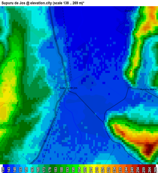
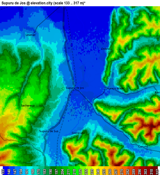
Below is the Elevation map of Supuru de Jos, which displays elevation range with different colors. Scale of the first map is from 138 to 269 m (453 to 883 ft) with average elevation of 163.6 meters (=537 ft) [note 1]
These maps also provides idea of topography and contour of this city, they are displayed at different zoom levels. More info about maps, scale and edge coordinates you can find below images.
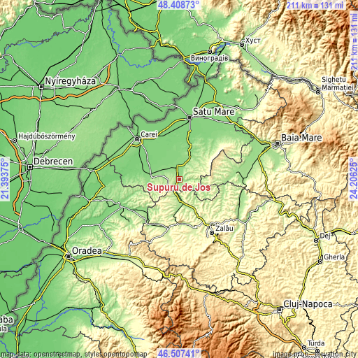
| \ | Map #1 | Map #2 | Topo.Map |
| Scale [m] | 138..269 m | 133..317 m | × |
| Scale [ft] | 453..883 ft | 436..1040 ft | × |
| Average | 163.6 m = 537 ft | 184.2 m = 604 ft | × |
| Width | 6.61 km = 4.1 mi | 13.21 km = 8.2 mi | 211.4 km = 131.4 mi |
| Height | 6.61 km = 4.1 mi | 13.21 km = 8.2 mi | 211.4 km = 131.4 mi |
| ↑Max Latitude | 47.496369° | 47.526052° | 48.40873° |
| Latitude at center | 47.46667° | 47.46667° | 47.46667° |
| ↓Min Latitude | 47.436954° | 47.407221° | 46.50741° |
| ← Min Longitude | 22.756055° | 22.712109° | 21.39375° |
| Longitude center | 22.8° | 22.8° | 22.8° |
| →Max Longitude | 22.843945° | 22.887891° | 24.20625° |
Nearby cities:
Cities around Supuru de Jos sort by population:
• Şărmăşag elevation 234 m
13.2 km,  169°
169°
• Bobota 184 m
9.6 km,  195°
195°
• Beltiug 166 m
10 km,  22°
22°
• Bogdand 178 m
11.5 km,  119°
119°
• Chieşd 187 m
11.2 km,  145°
145°
• Derșida 169 m
8.7 km,  179°
179°
• Dobra 142 m
3.8 km,  33°
33°
• Săcăşeni 152 m
9 km,  281°
281°
• Sărăuad 171 m
13.2 km, 276°
• Stâna 221 m
13.2 km,  69°
69°
• Babța 243 m
10.8 km,  95°
95°
• Acâş 139 m
7.5 km,  350°
350°
Multilingual:
 En español:
Supuru de Jos elevación 145 m.
 En France:
Supuru de Jos élévation 145 m.
 Auf Deutsch:
Supuru de Jos höhe über dem Meeresspiegel ist 145 m.

Sources and notes:
- [note 1] Map square and city borders are not equal. Map elevation data is calculated only from area inside that square.
- [src 1] Elevation data from geonames database provided with same terms of usage.
- [src 2] The elevation map of Supuru de Jos is generated using elevation data from NASA's 3 arcsec (90m) resolution SRTM data.
- [src 3] Base (background) map © OpenStreetMap contributors tiles are generated by Geofabrik and OpenTopoMap.
Copyright & License:
This Supuru de Jos Elevation Map is licensed under CC BY-SA. You may reuse any part from this page, if you give a proper credit by linking to this URL:
 More info on terms of use page.