Șurdești elevation
Șurdești (Maramureş, Comuna Şişeşti), Romania elevation is 427 meters and Șurdești elevation in feet is 1401 ft above sea level [src 1]. Șurdești is a populated place (feature code) with elevation that is 175 meters (574 ft) bigger than average city elevation in Romania.
Below is the Elevation map of Șurdești, which displays elevation range with different colors. Scale of the first map is from 314 to 775 m (1030 to 2543 ft) with average elevation of 480.2 meters (=1575 ft) [note 1]
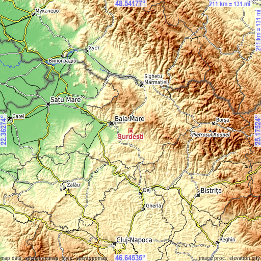
These maps also provides idea of topography and contour of this city, they are displayed at different zoom levels. More info about maps, scale and edge coordinates you can find below images.
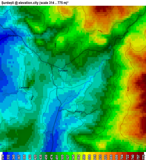
| \ | Map #1 | Topo.Map |
| Scale [m] | 314..775 m | × |
| Scale [ft] | 1030..2543 ft | × |
| Average | 480.2 m = 1575 ft | × |
| Width | 6.59 km = 4.1 mi | 210.9 km = 131 mi |
| Height | 6.59 km = 4.1 mi | 210.8 km = 131 mi |
| ↑Max Latitude | 47.631773° | 48.54177° |
| Latitude at center | 47.60215° | 47.60215° |
| ↓Min Latitude | 47.57251° | 46.64535° |
| ← Min Longitude | 23.725045° | 22.36274° |
| Longitude center | 23.76899° | 23.76899° |
| →Max Longitude | 23.812935° | 25.17524° |
Nearby cities:
Cities around Șurdești sort by population:
• Baia Sprie elevation 350 m
8.8 km,  319°
319°
• Copalnic Mănăştur 321 m
13.1 km,  209°
209°
• Cavnic 859 m
10.2 km,  45°
45°
• Dumbrăviţa 197 m
8.9 km,  268°
268°
• Cerneşti 306 m
9.6 km,  188°
188°
• Cupşeni 488 m
13.6 km,  115°
115°
• Tăuții de Sus 298 m
10.3 km,  306°
306°
• Groşi 235 m
11.5 km,  278°
278°
• Ungureni 387 m
15.1 km,  114°
114°
• Șisești 368 m
5.9 km, 308°
• Coaș 200 m
15.4 km,  243°
243°
• Borcut 343 m
14.4 km,  158°
158°
Multilingual:
 En español:
Șurdești elevación 427 m.
 En France:
Șurdești élévation 427 m.
 Auf Deutsch:
Șurdești höhe über dem Meeresspiegel ist 427 m.

Sources and notes:
- [note 1] Map square and city borders are not equal. Map elevation data is calculated only from area inside that square.
- [src 1] Elevation data from geonames database provided with same terms of usage.
- [src 2] The elevation map of Șurdești is generated using elevation data from NASA's 3 arcsec (90m) resolution SRTM data.
- [src 3] Base (background) map © OpenStreetMap contributors tiles are generated by Geofabrik and OpenTopoMap.
Copyright & License:
This Șurdești Elevation Map is licensed under CC BY-SA. You may reuse any part from this page, if you give a proper credit by linking to this URL:
 More info on terms of use page.