Ţigănaşi elevation
Ţigănaşi (Iaşi, Comuna Ţigănaşi), Romania elevation is 74 meters and Ţigănaşi elevation in feet is 243 ft above sea level [src 1]. Ţigănaşi is a seat of a second-order administrative division (feature code) with elevation that is 178 meters (584 ft) smaller than average city elevation in Romania.
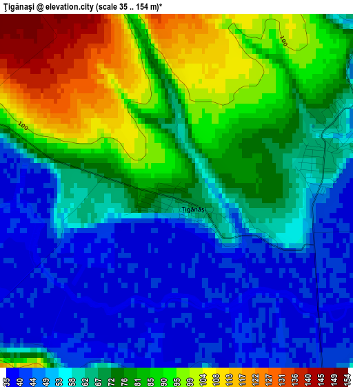
Below is the Elevation map of Ţigănaşi, which displays elevation range with different colors. Scale of the first map is from 35 to 154 m (115 to 505 ft) with average elevation of 69.3 meters (=227 ft) [note 1]
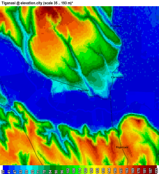
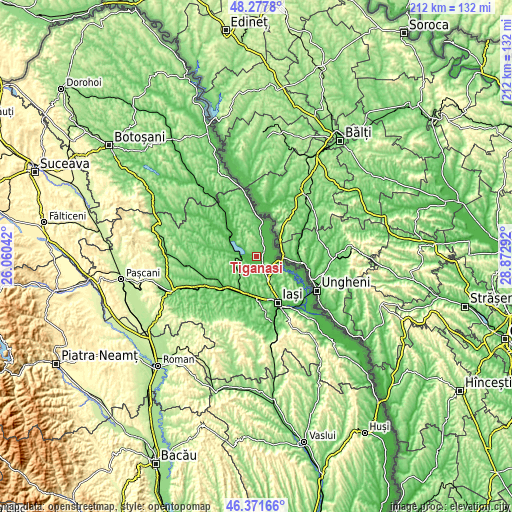
These maps also provides idea of topography and contour of this city, they are displayed at different zoom levels. More info about maps, scale and edge coordinates you can find below images.
| \ | Map #1 | Map #2 | Topo.Map |
| Scale [m] | 35..154 m | 35..193 m | × |
| Scale [ft] | 115..505 ft | 115..633 ft | × |
| Average | 69.3 m = 227 ft | 86.7 m = 284 ft | × |
| Width | 6.62 km = 4.1 mi | 13.25 km = 8.2 mi | 211.9 km = 131.7 mi |
| Height | 6.62 km = 4.1 mi | 13.25 km = 8.2 mi | 211.9 km = 131.7 mi |
| ↑Max Latitude | 47.363105° | 47.392863° | 48.2778° |
| Latitude at center | 47.33333° | 47.33333° | 47.33333° |
| ↓Min Latitude | 47.303538° | 47.27373° | 46.37166° |
| ← Min Longitude | 27.422725° | 27.378779° | 26.06042° |
| Longitude center | 27.46667° | 27.46667° | 27.46667° |
| →Max Longitude | 27.510615° | 27.554561° | 28.87292° |
Nearby cities:
Cities around Ţigănaşi sort by population:
• Popricani elevation 143 m
5.3 km,  134°
134°
• Rediu 142 m
13.2 km,  169°
169°
• Trifeşti 44 m
13.5 km,  16°
16°
• Vlădeni 49 m
13.7 km,  312°
312°
• Victoria 103 m
10.4 km,  122°
122°
• Probota 77 m
6.1 km, 24°
• Movileni 88 m
9 km,  258°
258°
• Perieni 95 m
5.7 km,  5°
5°
• Vânători 69 m
12.2 km,  155°
155°
• Cârniceni 64 m
3 km,  76°
76°
• Breazu 90 m
13.9 km, 163°
• Româneşti 92 m
12.6 km,  243°
243°
Multilingual:
 En español:
Ţigănaşi elevación 74 m.
 En France:
Ţigănaşi élévation 74 m.


Sources and notes:
- [note 1] Map square and city borders are not equal. Map elevation data is calculated only from area inside that square.
- [src 1] Elevation data from geonames database provided with same terms of usage.
- [src 2] The elevation map of Ţigănaşi is generated using elevation data from NASA's 3 arcsec (90m) resolution SRTM data.
- [src 3] Base (background) map © OpenStreetMap contributors tiles are generated by Geofabrik and OpenTopoMap.
Copyright & License:
This Ţigănaşi Elevation Map is licensed under CC BY-SA. You may reuse any part from this page, if you give a proper credit by linking to this URL:
 More info on terms of use page.