Târgşoru Vechi elevation
Târgşoru Vechi (Prahova, Comuna Târgşoru Vechi), Romania elevation is 162 meters and Târgşoru Vechi elevation in feet is 531 ft above sea level [src 1]. Târgşoru Vechi is a seat of a second-order administrative division (feature code) with elevation that is 90 meters (295 ft) smaller than average city elevation in Romania.
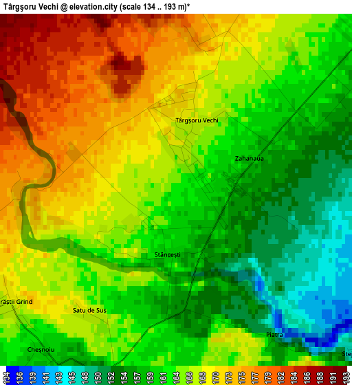
Below is the Elevation map of Târgşoru Vechi, which displays elevation range with different colors. Scale of the first map is from 134 to 193 m (440 to 633 ft) with average elevation of 164.6 meters (=540 ft) [note 1]
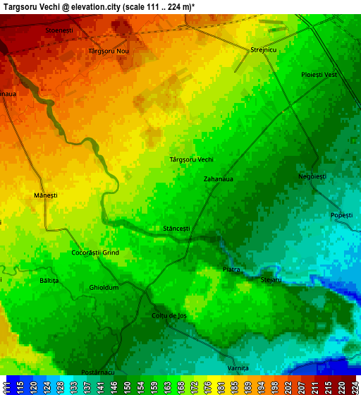
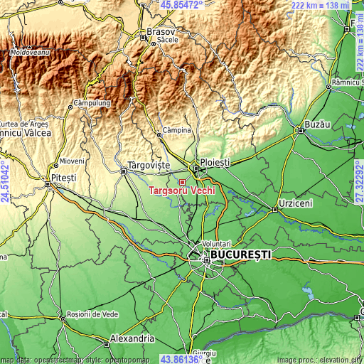
These maps also provides idea of topography and contour of this city, they are displayed at different zoom levels. More info about maps, scale and edge coordinates you can find below images.
| \ | Map #1 | Map #2 | Topo.Map |
| Scale [m] | 134..193 m | 111..224 m | × |
| Scale [ft] | 440..633 ft | 364..735 ft | × |
| Average | 164.6 m = 540 ft | 165.1 m = 542 ft | × |
| Width | 6.93 km = 4.3 mi | 13.85 km = 8.6 mi | 221.6 km = 137.7 mi |
| Height | 6.93 km = 4.3 mi | 13.85 km = 8.6 mi | 221.6 km = 137.7 mi |
| ↑Max Latitude | 44.897808° | 44.928929° | 45.85472° |
| Latitude at center | 44.86667° | 44.86667° | 44.86667° |
| ↓Min Latitude | 44.835515° | 44.804344° | 43.86136° |
| ← Min Longitude | 25.872725° | 25.828779° | 24.51042° |
| Longitude center | 25.91667° | 25.91667° | 25.91667° |
| →Max Longitude | 25.960615° | 26.004561° | 27.32292° |
Nearby cities:
Cities around Târgşoru Vechi sort by population:
• Brazii de Sus elevation 132 m
7.9 km,  90°
90°
• Măneşti 184 m
5.3 km,  270°
270°
• Şirna 133 m
7.9 km,  160°
160°
• Strejnicu 177 m
6.2 km,  25°
25°
• Tinosu 113 m
9.6 km,  125°
125°
• Tăriceni 123 m
8.9 km,  151°
151°
• Negoiești 146 m
5.2 km,  81°
81°
• Popești 136 m
6.3 km,  96°
96°
• Stoenești 212 m
7.9 km,  324°
324°
• Varnița 139 m
7 km, 161°
• Coada Izvorului 179 m
7.8 km,  262°
262°
• Cocorăștii Colț 155 m
3.9 km,  200°
200°
Multilingual:
 En español:
Târgşoru Vechi elevación 162 m.
 En France:
Târgşoru Vechi élévation 162 m.
 Auf Deutsch:
Târgşoru Vechi höhe über dem Meeresspiegel ist 162 m.

Sources and notes:
- [note 1] Map square and city borders are not equal. Map elevation data is calculated only from area inside that square.
- [src 1] Elevation data from geonames database provided with same terms of usage.
- [src 2] The elevation map of Târgşoru Vechi is generated using elevation data from NASA's 3 arcsec (90m) resolution SRTM data.
- [src 3] Base (background) map © OpenStreetMap contributors tiles are generated by Geofabrik and OpenTopoMap.
Copyright & License:
This Târgşoru Vechi Elevation Map is licensed under CC BY-SA. You may reuse any part from this page, if you give a proper credit by linking to this URL:
 More info on terms of use page.